Arctic Sea Ice Shrinks to Its 2026 Minimum

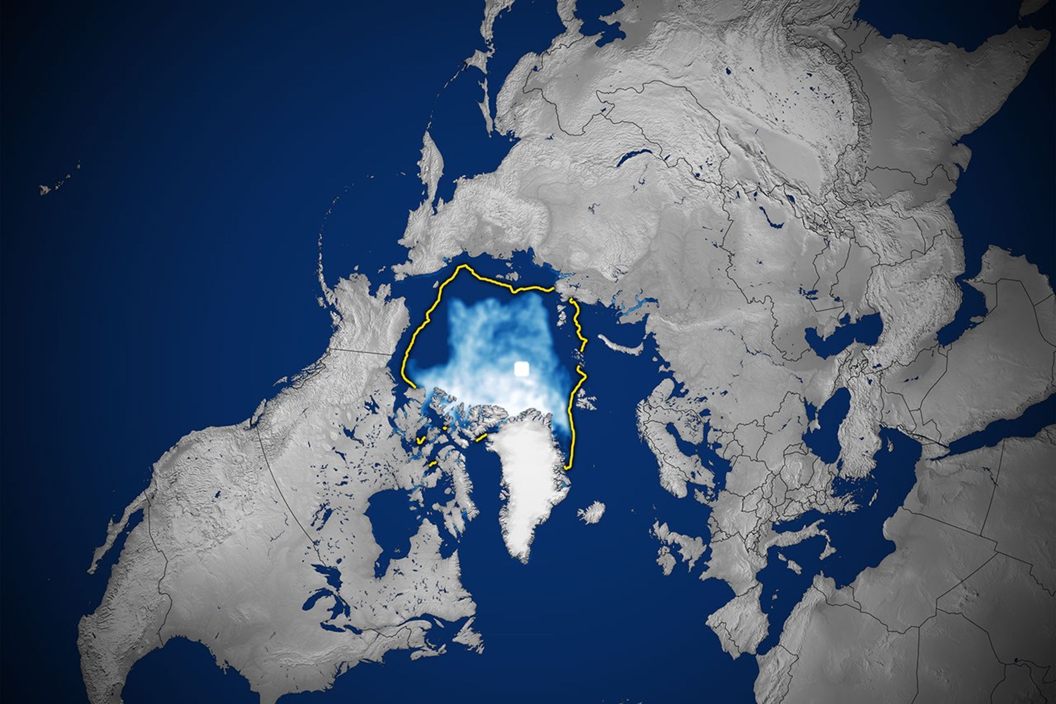
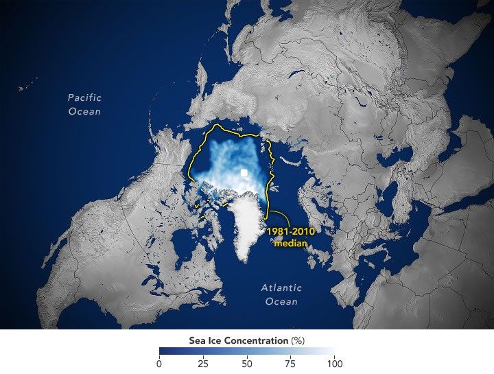
A map of the shows sea ice in September 2026 covering a smaller area than the 1981–2010 median, which is outlined in yellow.
Arctic sea ice reaches its annual minimum extent on September 12, 2026, tying several past years for the 10th-lowest minimum in the satellite record.
NASA Earth Observatory/Michala Garrison

This story is an update to the Arctic sea ice feature in our World of Change series, which tracks long-term change on Earth’s surface through satellite imagery.

A layer of frozen seawater caps the Arctic Ocean. This sea ice grows through the long polar winter, usually peaking in March, then melts through the summer to its annual low in September. It is a natural fluctuation that has persisted for millennia. But satellite records show the ice now covers less of the Arctic Ocean at its annual maximum and minimum than it did a few decades ago.

Sea ice in 2026 reached its annual minimum extent on September 12 (above), when it covered an estimated 4.6 million square kilometers (1.78 million square miles), according to NASA and the National Snow and Ice Data Center (NSIDC). That ties 2008, 2010, and 2025 for the 10th-lowest minimum in the satellite record.

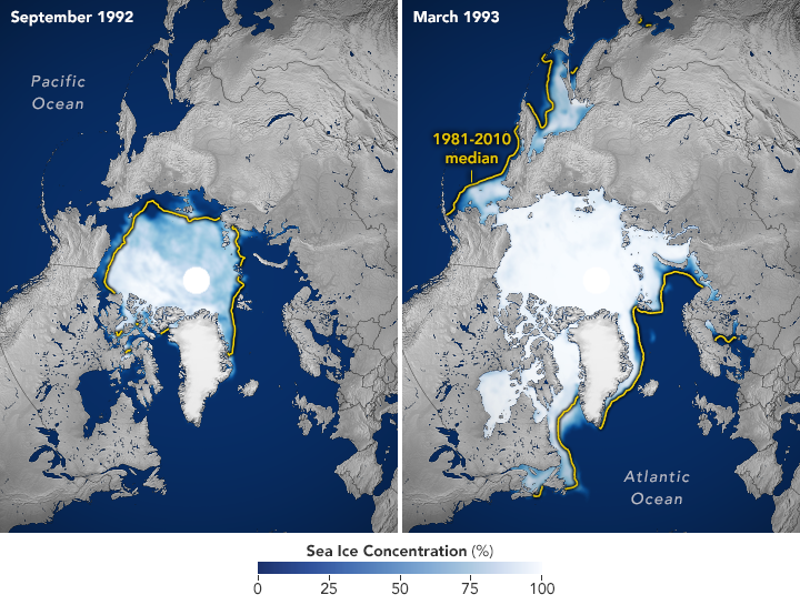
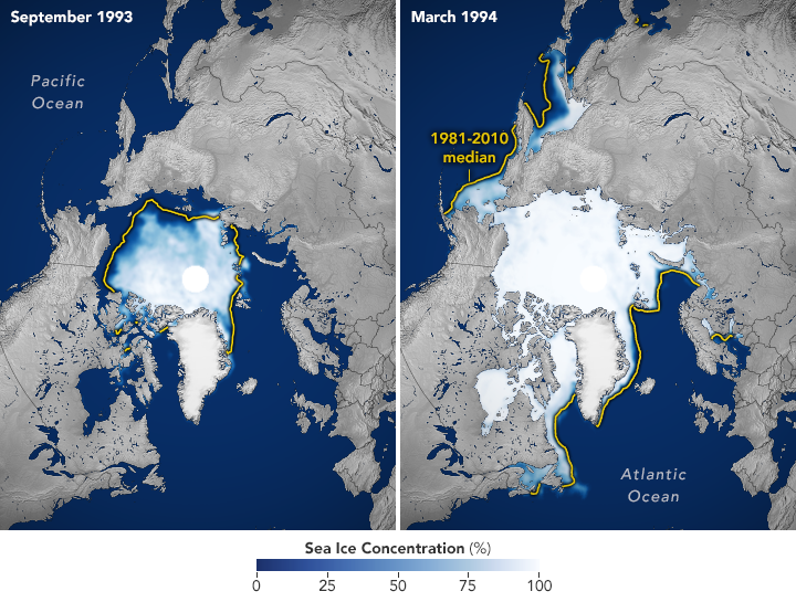
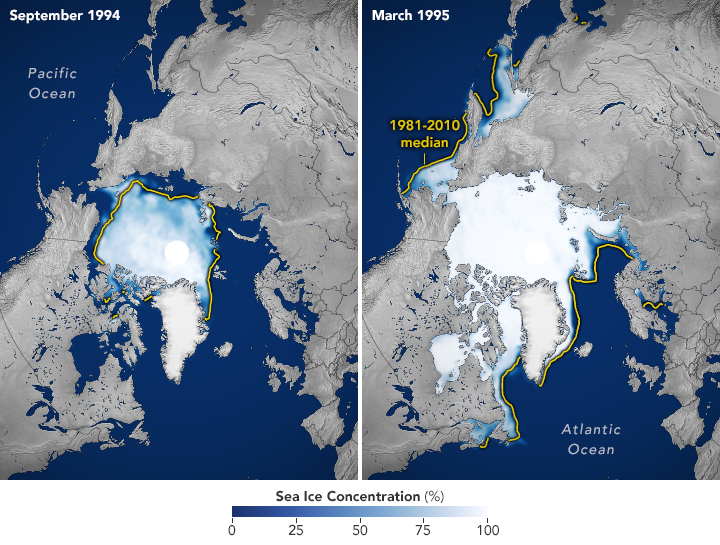
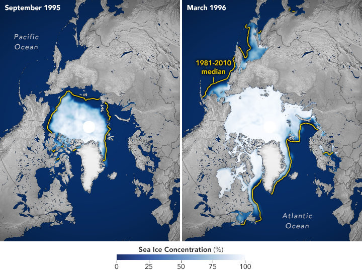
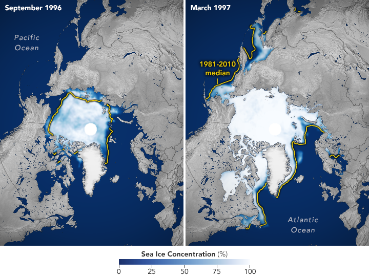
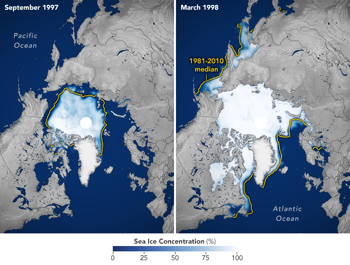
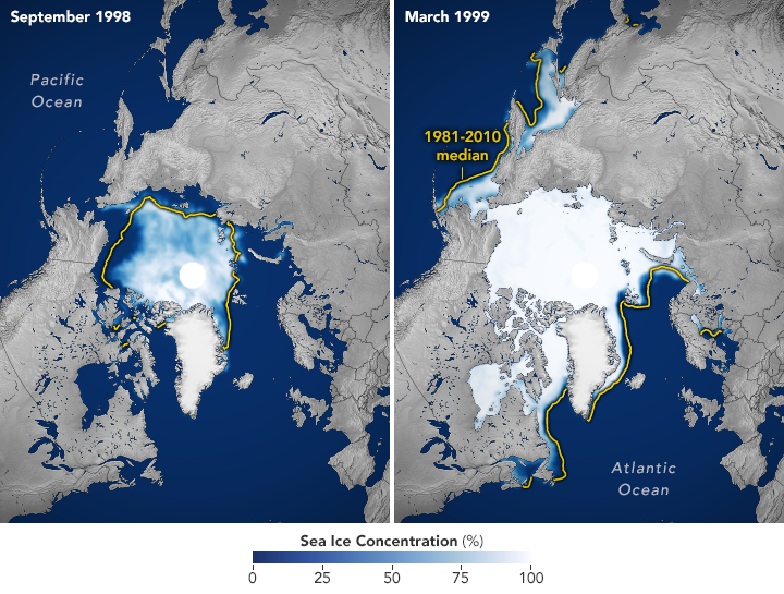
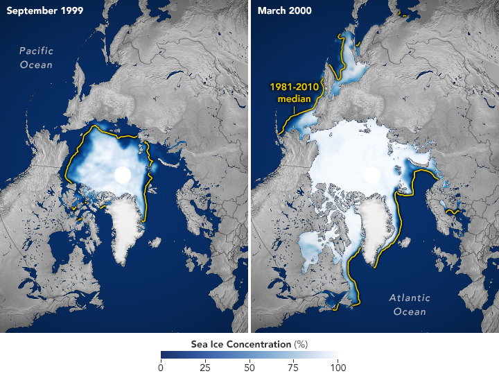
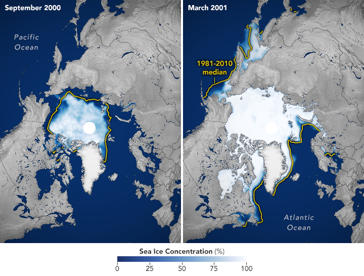
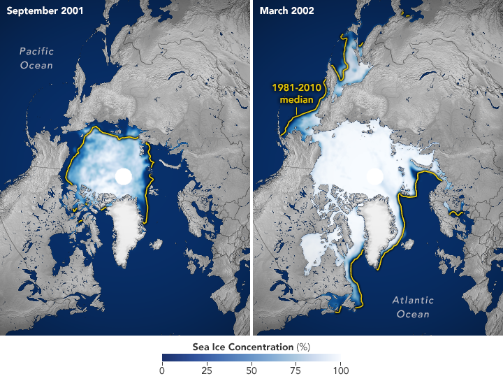
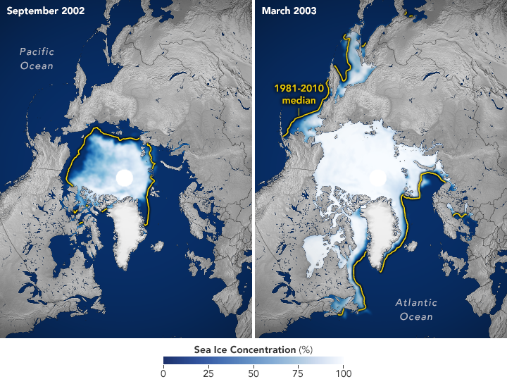
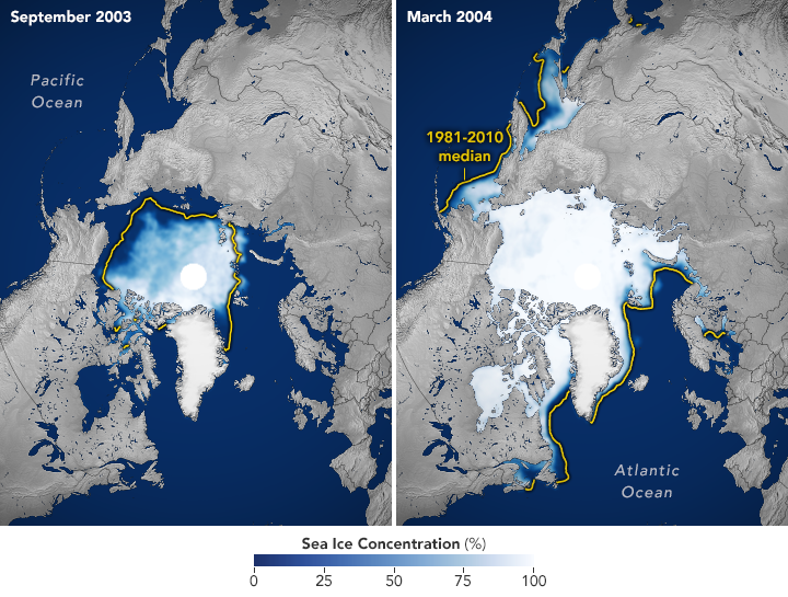
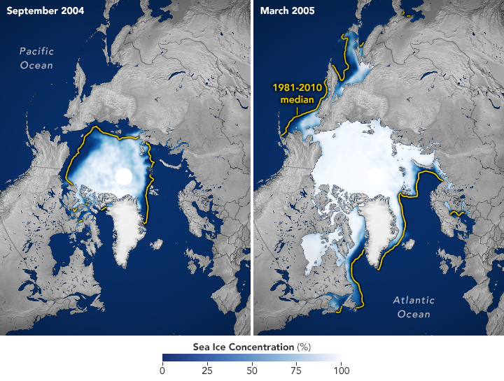
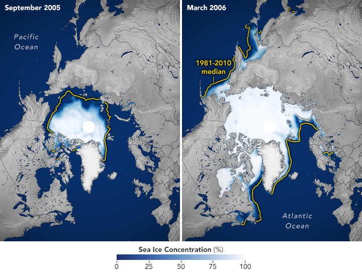
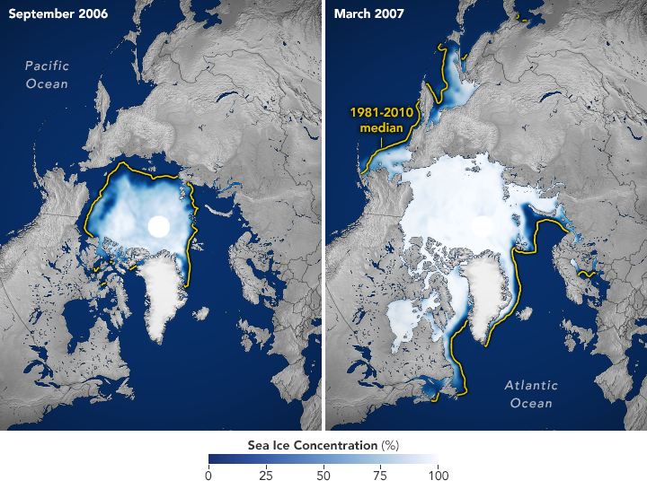
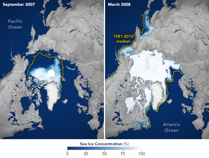
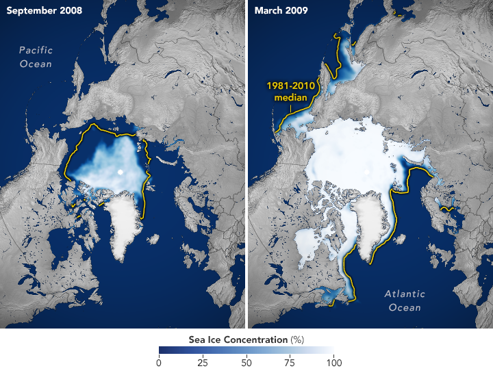
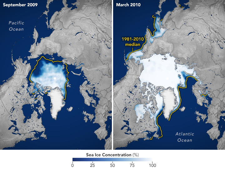
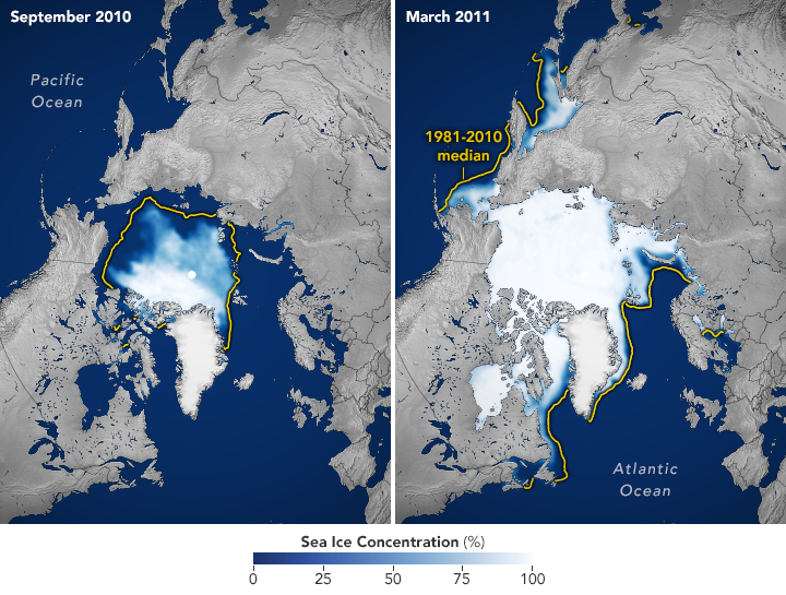
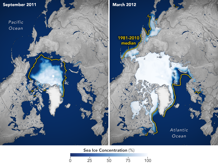
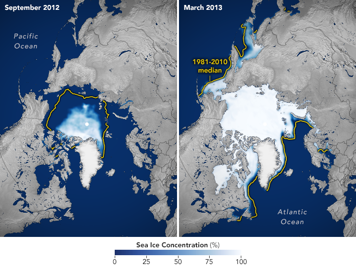
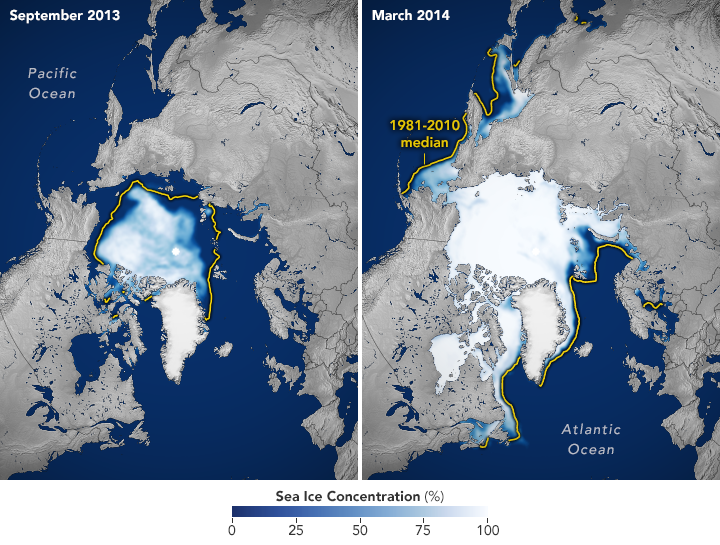
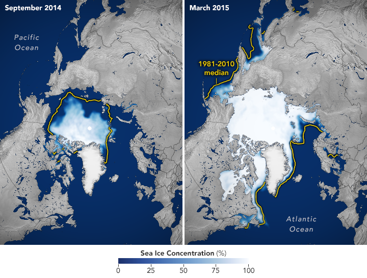
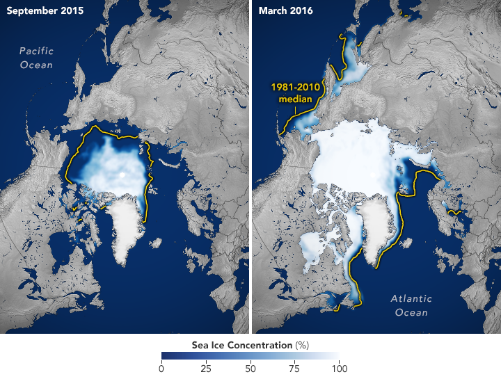
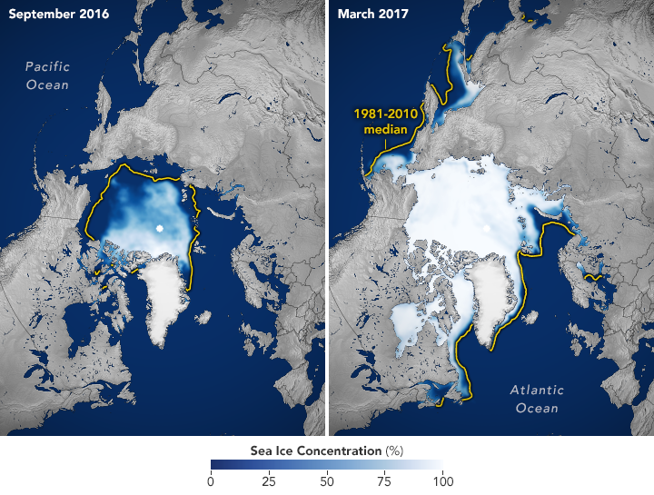
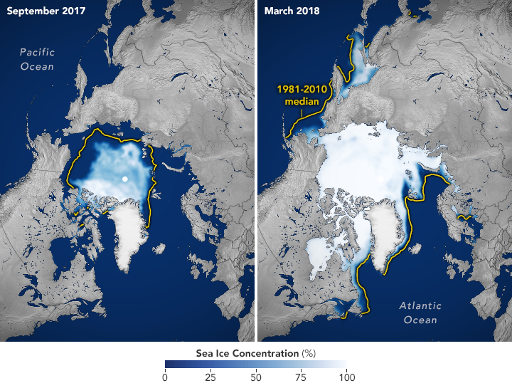
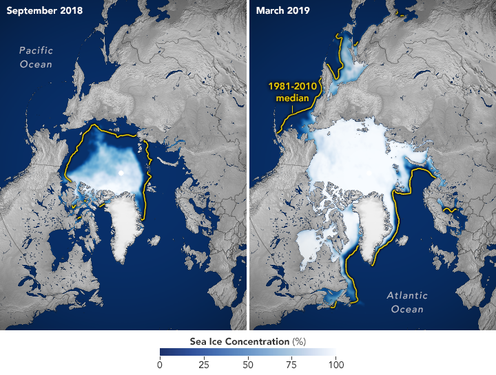
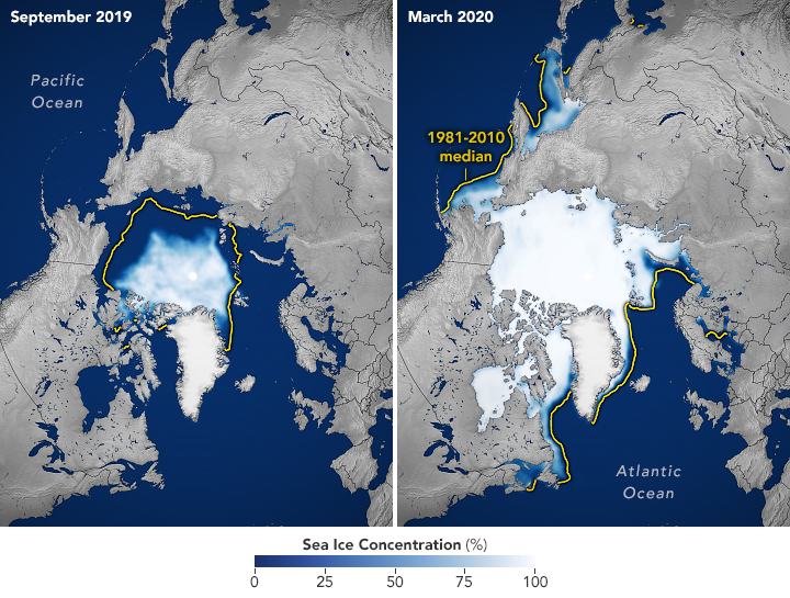
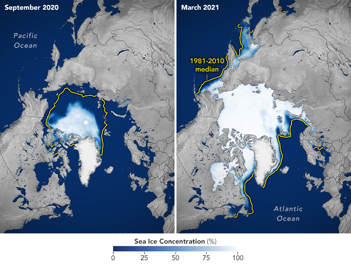
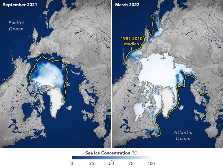
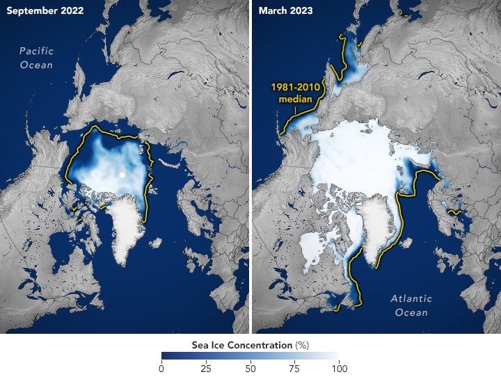
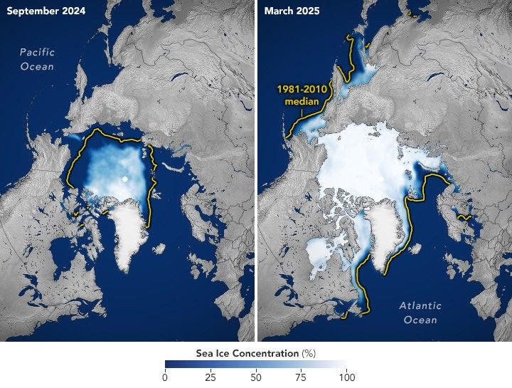
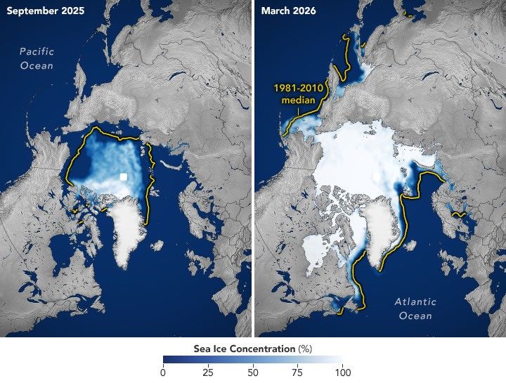
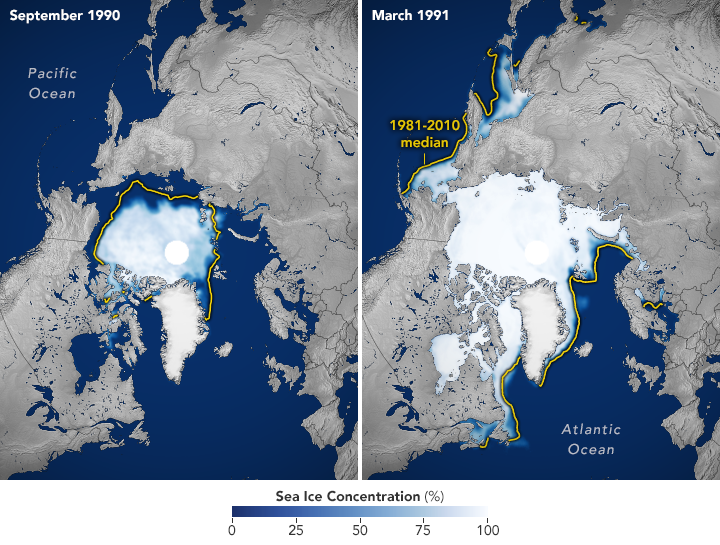
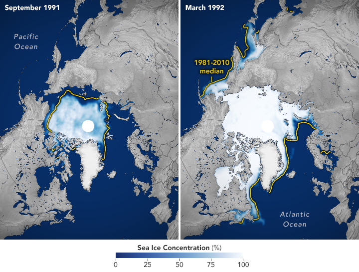
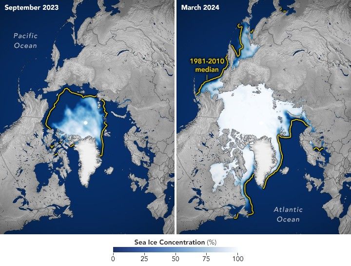
The maps below pair each September since 1990 (left), around the ice’s annual minimum, with the following March (right), near its annual maximum, through March 2026.
Lower Lows, Thinner Ice

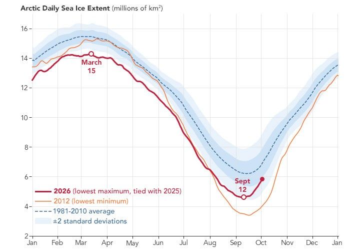
Scientists have used satellites to observe the annual growth and retreat of Arctic sea ice continuously since late 1978. While sea ice extent has declined overall during that time, the downward trend steepened in the 2000s and set off a run of record and near-record lows. Each of the past 20 summers, from 2007 through 2026, ranks among the 20 lowest minimum extents in the satellite record. The lowest occurred in September 2012.

More recently, the September sea ice extent has been relatively steady. Weather can make a big difference in how much ice melts from one summer to the next. For example, over the past decade, increased cloud cover has prevented sunlight from accelerating the melt, according to NASA scientists. Despite this recent plateau, the summer minimum remains well below the long-term average.

Across the Arctic, the ice that remains is younger and thinner. Observations show a decline in multiyear ice—that which survives at least one melt season—leaving an Arctic dominated by thinner first-year ice. Winter ice is also shrinking. The March 2026 maximum statistically tied the 2025 maximum for the lowest in the satellite record.

A line chart of Arctic sea ice extent shows the 1981–2010 average as a blue dashed line, 2012 (the record-low minimum year) in orange, and 2026 in red. The 2026 line stays below the average and peaks in March at a level that tied 2025 for the lowest maximum on record.

Cycles of natural variability such as the Arctic Oscillation are known to play a role in Arctic sea ice extent, but the decline observed throughout the satellite record cannot be explained by natural variability alone. Natural variability and rising global temperatures have worked together to melt greater amounts of Arctic sea ice. Scientists have projected an essentially ice-free Arctic could occur at least once before the middle of the 21st century.

Seeing Through the Clouds

To determine sea ice extent, scientists rely on satellites with passive microwave sensors that measure the microwave energy Earth naturally emits. Sea ice emits more of this energy than open water, so it stands out in microwave images. Because microwaves pass through clouds, the satellites can observe sea ice regularly, regardless of weather.

The record began in 1978 with data collected by NASA’s Nimbus-7, followed by Defense Meteorological Satellite Program (DMSP) satellites starting in 1987 and NASA’s Aqua satellite between 2002 and 2011. Starting in 2025, scientists began using observations from the Japan Aerospace Exploration Agency’s GCOM-W satellite. The white circle at the center of each image is the “pole hole,” north of which satellite sensors have historically been unable to collect data. The sea ice estimates assume that this hole is ice-filled.

NASA Earth Observatory images by Michala Garrison, using data from the National Snow and Ice Data Center.

References & Resources

You may also be interested in:

Stay up-to-date with the latest content from NASA as we explore the universe and discover more about our home planet.

Arctic Melt Season Length Levels Off

4 min read

While the sea ice melt season has lengthened dramatically in most of the satellite era, the trend unexpectedly stabilized around…

Article

A Changing World for Emperor Penguins

7 min read

Experts are analyzing decades of images from Landsat satellites for clues about how the iconic birds have responded to sea…

Article

Pink Penguin Guano Provides Diet Clues

3 min read

The color of Adélie penguin droppings reveals what the birds are eating, offering scientists a way to track how sea…

Article

Source: science.nasa.gov

APOD: 2026 October 7 – Supernova Remnant Pa 30

APOD

Astronomy Picture of the Day

Discover the cosmos! Each day a different image or photograph of our fascinating universe is featured, along with a brief explanation written by a professional astronomer.

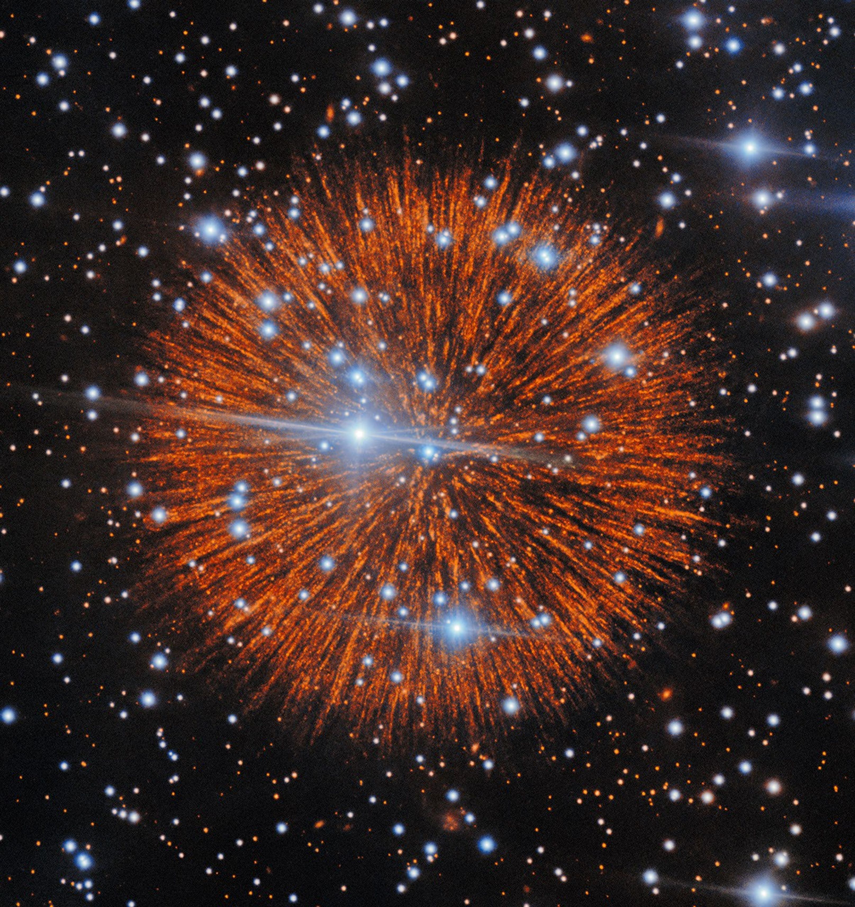
A red explosion extending radially like a firework over a dark field of stars.

Supernova Remnant Pa 30

Explanation: “Happy New Year!” No, wait, this is not a fireworks display. This image shows Nebula Pa 30, observed with the Gemini North Telescope in Hawai’i. It is likely the remnant of an old supernova explosion: separate historical records by Chinese, Japanese and Arabic astronomers tell of a “guest star” that appeared in the sky for 185 days in the year 1181. It is believed that this bright new point of light came from the supernova that caused the fireworks in Pa 30. Astronomers don’t know exactly what happened in this unusual explosion, classified as a Type Iax supernova, but it is thought to be caused by the merger of two white dwarfs. The mysterious central star in the image is extremely hot and produces a strong wind, possibly forming the radial filaments. Look closely at them: those pearl-like knots stringing the filaments are 4 light-days in diameter. Understanding how a supernova created this amazing nebula continues an 845-year old mystery (and counting).

Tomorrow’s picture: smörgåsbord

Date October 7, 2026
Credit & License International Gemini Observatory/NOIRLab/NSF/AURA. Acknowledgment: PI: T. Cunningham (Center for Astrophysics – Harvard & Smithsonian). Image Processing: J. Miller & M. Rodriguez (International Gemini Observatory/NSF NOIRLab), T.A. Rector (University of Alaska Anchorage/NSF NOIRLab), D. de Martin & M. Zamani (NSF NOIRLab).
Authors & editors: Cecilia Chirenti, Robert Nemiroff, Jerry Bonnell, Keighley Rockcliffe
A service of: ASD at NASA / GSFC,
NASA Science Activation & Michigan Tech. U.

Source: science.nasa.gov

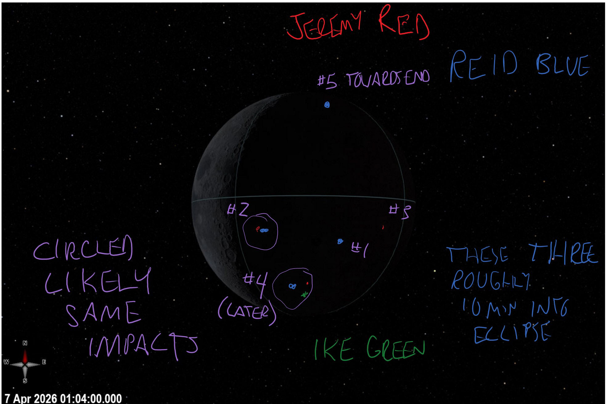
Artemis II Crew Moon Photo Annotations

A simulated image of the crew’s view of the dark, eclipsed Moon on April 6, 2026. Three crew members annotated impact flashes on this image in OneNote. Reid Wiseman wrote in blue. Victor “Ike” Glover wrote in green. Jeremy Hansen wrote in red. General annotations are in purple ink. A note on the left side in purple is “circled likely same impacts.” Five impact flashes are numbered across the Moon. #1 with a blue dot (observed by Wiseman) is located at the 4 o’clock position, but more central. #2 is circled with a red dot (observed by Hansen) and a blue dot (observed by Wiseman) is located at the 8’clock position, but near the Moon’s center. #3 with a red dot (observed by Hansen) is located at 3 o’clock. #4 is circled with a red dot (observed by Hansen), a blue dot (observed by Wiseman), and a green dot (observed by Glover). It is at the 6 o’clock position. A note of “(later)” is under #4. #5 with a blue dot (observed by Wiseman) is located at the 12 o’clock position. A note of “towards end” is to the right of #5. Wiseman wrote an additional note in blue: “these three roughly 10 min into eclipse.” The three indicated are the blue dots at #1, #2, and #4.
NASA

A visualization of a dark Moon eclipsing the Sun is marked with handwritten notes in this April 6, 2026, screenshot from an Artemis II crew member’s tablet.

NASA astronauts Reid Wiseman (in blue) and Victor “Ike” Glover (in green) and CSA (Canadian Space Agency) Jeremy Hansen (in red) observed impact flashes and their locations, which are noted on the image. Overall, the astronauts reported seeing five extremely faint “pinprick” bursts of light from their view aboard Orion, which was 46,000 miles away from the Moon at the time. These flashes are sparked by rocky fragments hitting the Moon.

From April 1 through April 10, 2026, NASA’s Artemis II crew traveled to the Moon and back and along the way, captured stunning imagery and scientific observations of our nearest neighbor. Now, the full lunar science dataset from their journey is available to the global science community, and to the public, for further study. Read about the report, listen to crew audio observations, and explore more.

Image credit: NASA

Source: www.nasa.gov

NASA’s Curiosity Captures Dawn Breaking on Wind-Carved Cliffs

2 Min Read

NASA’s Curiosity Captures Dawn Breaking on Wind-Carved Cliffs

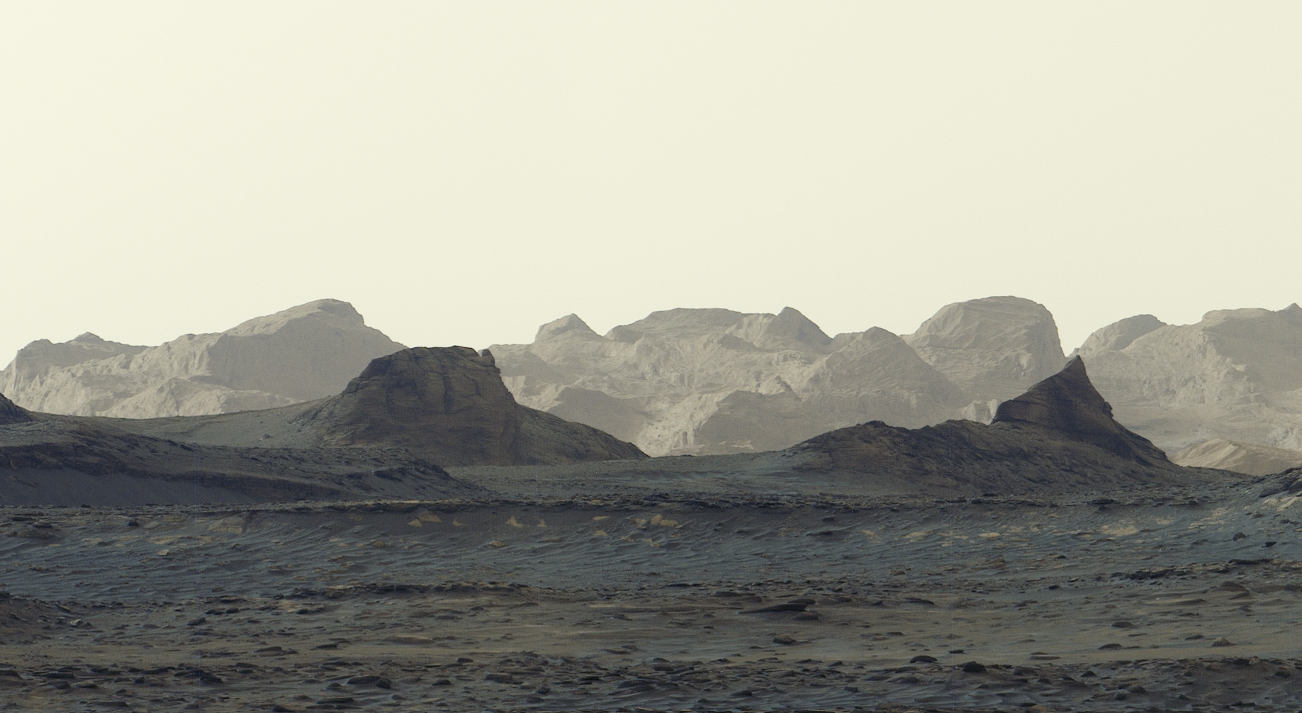
A panoramic view of a stark, grayish-tan Martian landscape featuring jagged rock formations and rolling mountain ridges beneath a pale, hazy sky.

PIA25629

Credits:
NASA/JPL-Caltech/MSSS

Description

NASA’s Curiosity Mars rover captured this panorama of sunrise illuminating distant, wind-carved features called yardangs on Aug. 11, 2026, the 4,982nd Martian day, or sol, of the mission. Scientists are eager to learn more about how the yardang layer formed.

A panoramic view of a stark, grayish-tan Martian landscape featuring jagged rock formations and rolling mountain ridges beneath a pale, hazy sky.
Figure A

Figure A is a crop zooming in on the distant yardangs.

Since 2014, Curiosity has been ascending 3-mile-tall (5-kilometer-tall) Mount Sharp, which is made up of a series of distinct layers that were deposited one on top of the other. In the area of the vast mountain’s shoulder where the rover is climbing, that stack of layers ends with the yardang layer. Before the yardang layer was laid down, Mount Sharp may have begun eroding, creating a gap in the otherwise continuous record of climate history that Curiosity has been reading from the layers. Scientists aren’t entirely sure how the layer formed; one theory is that it’s a pile of volcanic ash, similar to what’s seen along the Red Planet’s equator.

This panorama was captured by Curiosity’s Mastcam and is made up six individual images that were stitched together after being sent back to Earth. Unlike most of Curiosity’s Mastcam images, this one was processed without the usual white balancing, an artistic choice that preserves the early morning appearance.

Curiosity was built by NASA’s Jet Propulsion Laboratory, which is managed by Caltech in Pasadena, California. JPL leads the mission on behalf of NASA’s Science Mission Directorate in Washington as part of NASA’s Mars Exploration Program portfolio. Malin Space Science Systems in San Diego built and operates Mastcam.

To learn more about Curiosity, visit:

https://science.nasa.gov/mission/msl-curiosity/

Source: science.nasa.gov

NASA’s Curiosity Looks Back After Reaching Elevation Milestone

2 Min Read

NASA’s Curiosity Looks Back After Reaching Elevation Milestone

A wide panoramic view of a rocky, reddish-brown Martian valley framed by rugged hills under a hazy sky, with a portion of NASA’s Curiosity Mars visible on the far right.

PIA26781

Credits:
NASA/JPL-Caltech/MSSS

Description

NASA’s Curiosity Mars rover captured this view looking back at the floor of Gale Crater, with the crater’s rim visible in the distance, on Sept. 5, 2026, the 5,006th Martian day, or sol, of the mission. Just nine days prior, on Aug. 26 (Sol 4,996), Curiosity set a mission milestone by reaching 1 kilometer of elevation above the crater floor. Since 2014, Curiosity has been climbing the lower foothills of Mount Sharp, a 3-mile-tall (5-kilometer-tall) mountain located within Gale Crater. 

A sand ridge extends across the foreground of the image, and a trench left by the rover’s right front wheel is visible at right. Geologic layering inside the ridge, as well as the size and composition of its sand grains, will provide clues to how the feature formed.

This panorama is made up of 95 individual images taken by Curiosity’s Mast Camera, or Mastcam. The color in these images has been adjusted to match the lighting conditions as the human eye would see them on Earth.

Curiosity was built by NASA’s Jet Propulsion Laboratory, which is managed by Caltech in Pasadena, California. JPL leads the mission on behalf of NASA’s Science Mission Directorate in Washington as part of NASA’s Mars Exploration Program portfolio. Malin Space Science Systems in San Diego built and operates Mastcam.

To learn more about Curiosity, visit:

https://science.nasa.gov/mission/msl-curiosity/

Source: science.nasa.gov