Starstruck: NASA Research Shows How Sun’s Ancient History Shaped Earth

6 Min Read

Starstruck: NASA Research Shows How Sun’s Ancient History Shaped Earth

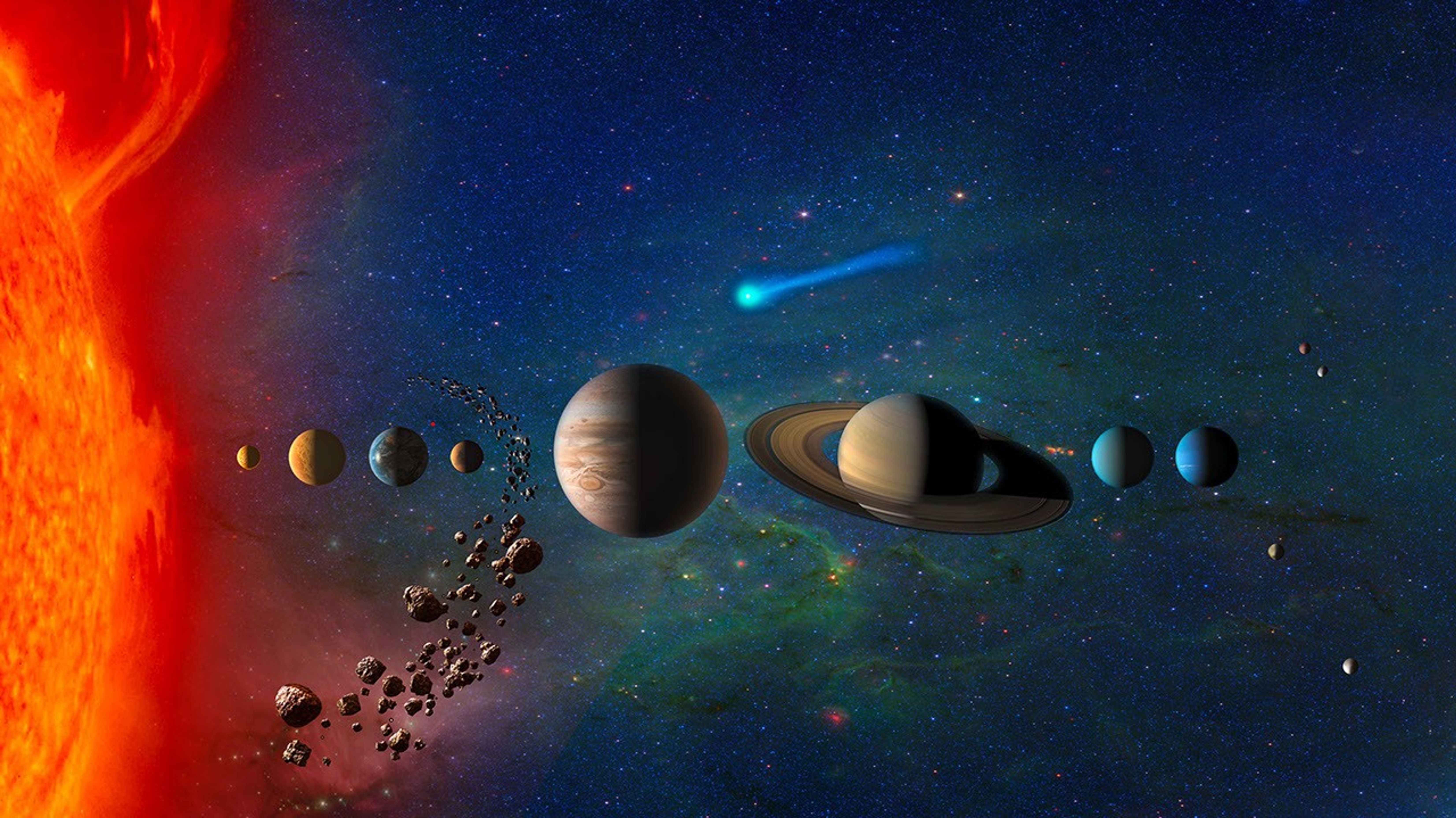
At the center of our solar system, the Sun influences every planet that orbits it. In two recent NASA-funded studies, scientists uncovered how ancient events in the Sun’s history may have helped create Earth’s unique climate and driven previously unexplained climatic shifts.  

In new research, scientists at NASA’s SHIELD (Solar Wind with Hydrogen Ion charge Exchange and Large-Scale Dynamics) center — one of NASA’s DRIVE (Diversify, Realize, Integrate, Venture, Educate) Science Centers — trace the trajectory of the heliosphere, the massive bubble created by our Sun that envelops our solar system, as it moved through our galaxy and influenced Earth’s climate along the way. In another paper, a NASA scientist and coauthors investigate how the younger, dimmer Sun managed to heat Earth by seeding the production of potent greenhouse gases.

A Sun on the move 

Over the last tens of millions of years, Earth’s climate has undergone significant shifts, including notable ice ages in which the global average temperature temporarily dropped by several degrees. During these periods, more frequent climate swings led Earth to warm and cool. To explain these periods of warming and cooling, scientists looked to factors internal to Earth, including orbital changes, greenhouse gases, and ice. But new research suggests changes to the Sun’s environment may be key to understanding Earth’s temperature swings. 

Just as our planet is encased by an atmosphere, so our entire solar system is encased inside a kind of “atmosphere” created by the Sun. This protective bubble, known as the heliosphere, is formed by a continuous solar wind of charged particles streaming out from the Sun in all directions. 

This conceptual animation begins with a view of the Milky Way Galaxy. As we zoom in, we travel to the Local Interstellar Cloud, and then to the heliosphere, the protective bubble that surrounds our solar system. The heliosphere is formed by a continuous stream of charged particles from the Sun, called the solar wind.
NASA’s Goddard Space Flight Center Conceptual Image Lab

Our heliosphere orbits around the center of our galaxy, the Milky Way. Throughout the Sun’s 4.6-billion-year existence, our heliosphere has traversed various regions within our galaxy. In a paper published on Aug. 21 in Annual Review of Astronomy and Astrophysics, researchers at NASA’s SHIELD used computer modeling to reverse-engineer the path of the heliosphere through our galaxy, revealing that the environments it passed through may have triggered changes on Earth.   

Merav Opher, SHIELD’s principal investigator at Boston University, and her team ran simulations that showed the Sun has encountered frigid expanses of gas and dust at least three different times in the past few million years. In these instances, massive interstellar “cold clouds” pushed against the heliosphere to such an extent that it shrank to smaller than Earth’s orbit, stranding our planet outside the Sun’s protective shield. 

These exposures — approximately 2 to 3 million years, 6 to 7 million years, and 13 to 14 million years ago — would have exposed Earth’s atmosphere to totally different surroundings. The simulation results match geologic evidence: Elements prevalent in interstellar dust appear in deep-sea sediment core samples, Antarctic snow, and lunar samples during these timelines. 

This animated illustration shows Earth and the Sun protected by the heliosphere, the massive bubble created by our Sun. As our solar system traverses through the galaxy, encounters with massive interstellar “cold clouds” pushed against the heliosphere and caused the heliosphere to shrink past Earth, exposing the planet to cosmic radiation and elements from interstellar space.
NASA’s SHIELD DRIVE Science Center/Merav Opher/Harvard Radcliffe Institute

These heliosphere collapse events may also explain ancient climatic patterns on Earth. In the simulations, when Earth’s atmosphere was exposed to a cold, dense galactic hydrogen cloud, it increased water vapor content and shifted upper-atmospheric dynamics, ultimately altering the conditions at the surface. In summary, our heliosphere’s trips through colder regions in our galaxy may be a key factor in driving some of Earth’s ancient changes in climate, including possible ice ages.  

Next frontier in studying heliophysics 

The SHIELD center is one of several that NASA funds to unlock the next generation of heliospheric research. As a DRIVE Science Center, SHIELD builds a team of researchers with differing expertise, approaches, and opinions to develop a model, or “digital twin,” of the heliosphere that helps reveal how the heliosphere interacts with its surroundings, including dense interstellar clouds. Understanding our unique, habitable solar system will help unravel the mysteries of life’s evolution on Earth and potentially uncover other habitable star systems. 

Young Sun 

In another paper, Vladimir Airapetian, a scientist at NASA’s Goddard Space Flight Center in Greenbelt, Maryland, focuses on a long-standing mystery of how the ancient Sun warmed early Earth enough to sustain life. Three billion years ago, the young Sun was 70% as bright as it is today. Under these dimmer conditions, Earth should have been frozen solid. Yet geological evidence shows stable liquid water already existed long before that. This puzzle — a balmy Earth under a cooler, dimmer Sun — is known as the Faint Young Sun paradox.  

One clue to resolving the paradox comes from young Sun-like stars elsewhere in the galaxy. These “toddler” stars are prone to throwing fits. Specifically, data from NASA’s retired Kepler space telescope shows that young Sun-like stars regularly erupt with massive superflares, flinging high-energy particles in all directions on a daily basis. If our young Sun was like these other stars, Airapetian proposes, the barrage of high-energy solar particles could have triggered chemical reactions that were key to warming early Earth. 

Airapetian’s team simulated early Earth’s atmosphere in a sealed chamber, mixing molecular nitrogen, ammonia, carbon dioxide, and carbon monoxide. They then fired protons into the mixture, simulating the onslaught of particles from superflares. This proton bombardment triggered several changes including the production of nitrous oxide, a greenhouse gas 300 times more potent than carbon dioxide. The research was published in Astrophysical Journal Letters.

This nitrous oxide could help Earth hold onto heat. But not all the nitrous oxide would last. The young Sun’s intense ultraviolet radiation would break some of it down, splitting the molecule back into nitrogen and oxygen. But even if only 10% of the nitrous observed in the experiment survived, Airapetian’s team’s computer simulations confirmed, it would still warm Earth’s equatorial regions to about 41 degrees Fahrenheit (5 degrees Celsius), above water’s freezing point. This smaller amount of nitrous could even accelerate prebiotic synthesis: just-above-freezing temperatures have been found to be more efficient for building complex chains of amino acids than warmer temperatures. 

Unearthing secrets of our star-planet system 

Together, these two studies show that the Sun can lead to surprising implications for Earth. While our planet stands alone in many ways, it was formed and has always existed as part of a star-planet system. Understanding that unique relationship promises new insights about both Earth and the star that sustains it.  

By Desiree Apodaca and Miles Hatfield 
NASA’s Goddard Space Flight Center, Greenbelt, Md. 

Keep Exploring

Discover More Topics From NASA

Source: science.nasa.gov

What’s Up: September 2026 Skywatching Tips from NASA

Brilliant Venus and a Harvest Moon

Use the Moon to find Antares and the Teapot, spot brilliant Venus, welcome the equinox, and see the Harvest Moon near Saturn and Neptune.

Skywatching Highlights

  • Sept. 14-20: Use the Moon to find Antares and the Teapot; dark skies may reveal the Milky Way center
  • Sept 18: Venus reaches peak brilliance for this evening appearance
  • Sept. 22: September equinox; fall begins in the Northern Hemisphere and spring in the Southern Hemisphere
  • Sept. 26: Harvest Moon rises near Saturn and Neptune
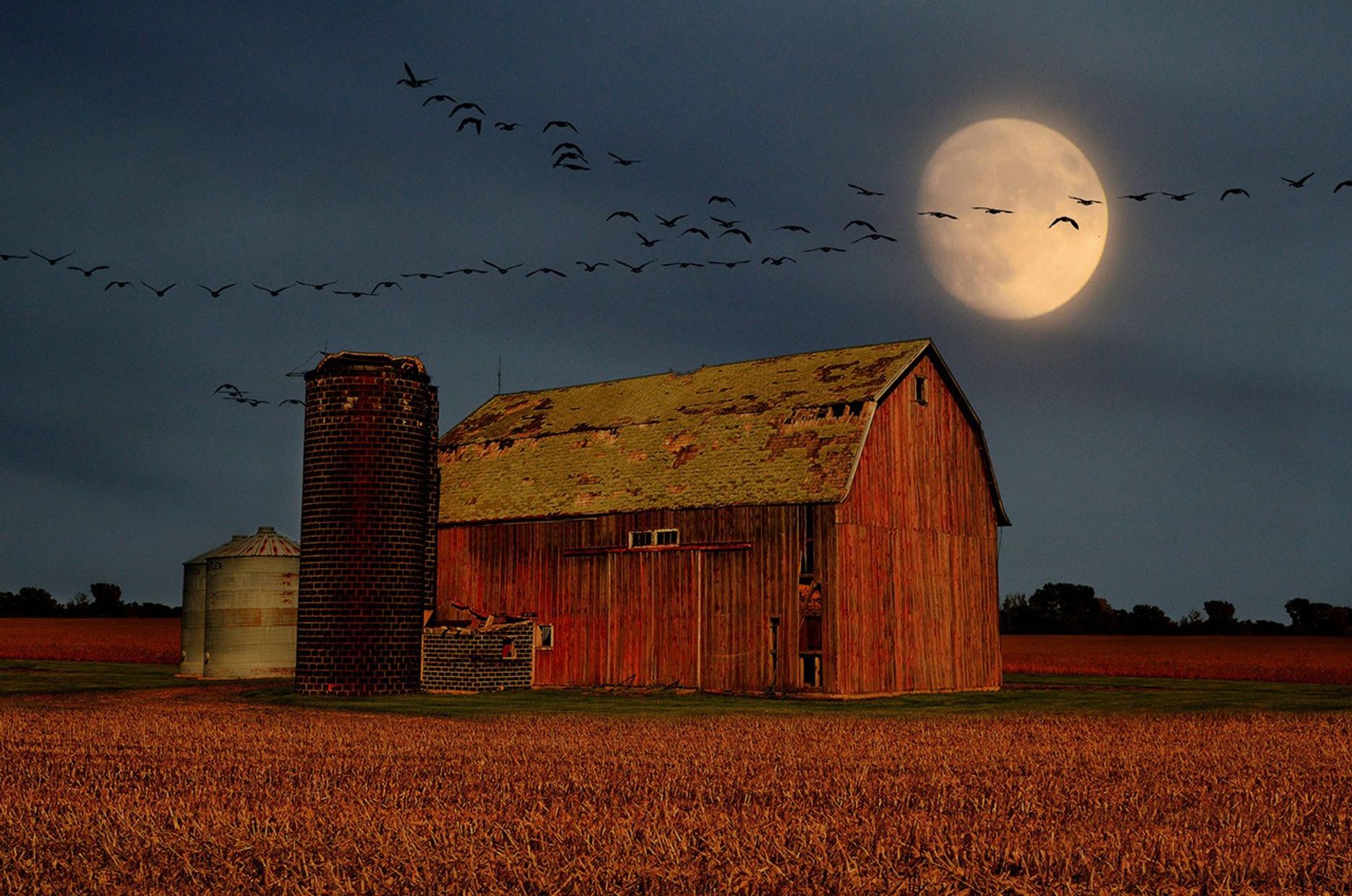
A large, glowing full moon shines bright yellow in a dark twilight sky above a rustic red barn and silo set behind a golden harvest field, with a long V-formation of birds flying across the sky.
Birds fly over a barn as a harvest Moon rises.
Mike Linnihan

Transcript

The Moon joins a tea party… Venus cranks up the brightness… the seasons officially change… and the Harvest Moon meets up with some planetary neighbors.

That’s What’s Up for September.

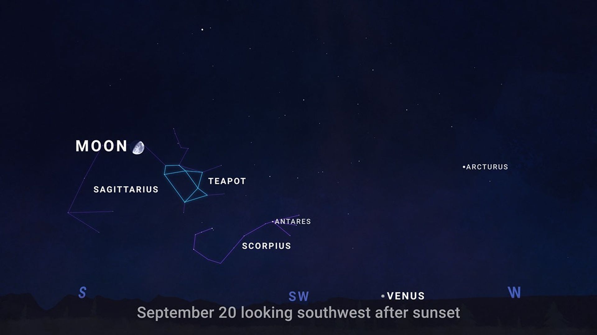
A sky chart looking southwest after sunset on Sept. 20, 2026.
NASA/JPL-Caltech

From September 14 through 20, let the Moon guide you to a few celestial landmarks. About an hour after sunset, look south to find the Moon in the evening sky.

Night by night, the Moon shifts position against the background stars, passing near Antares.

This bright, reddish star marks the heart of the constellation Scorpius.

Next you’ll see the Teapot, a group of stars in neighboring Sagittarius that really does resemble a teapot, complete with a handle, lid, and spout.

If you are under an especially dark sky… you may see hazy steam rising from the Teapot’s spout.
Follow that steam to its thickest part, and you’ll be looking toward the center of our Milky Way galaxy.

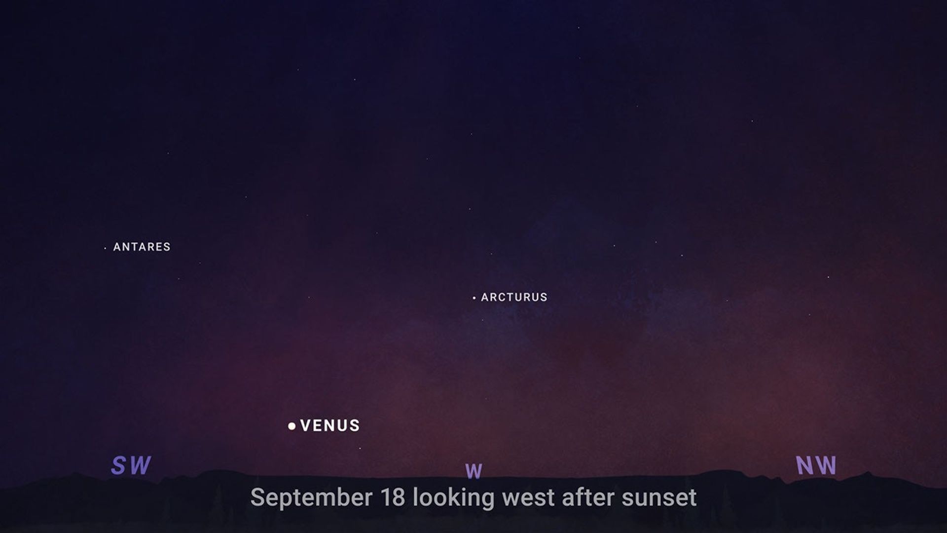
A sky chart looking west after sunset on Sept. 18, 2026.
NASA/JPL-Caltech

Look west on September 18 as Venus hits peak brilliance, shining at its brightest of this evening appearance..

You won’t have to search hard to find it. Shortly after sunset, Venus will stand out as a brilliant point of light low above the western horizon, outshining every star around it. A clear view of the horizon will give you the best chance to catch it before it sets.

On September 19, celebrate International Observe the Moon Night!

People around the world are invited to look up and connect with our nearest celestial neighbor while learning more about lunar science, exploration, and the many ways the Moon has shaped cultures around the world. Find an event near you — or learn how to participate from wherever you are — at go.nasa.gov/ObserveTheMoon.

Then on September 22, it’s officially fall in the Northern Hemisphere …while spring begins in the Southern Hemisphere.

That’s the September equinox, when the Sun is directly above Earth’s equator and day and night are close to equal in length around the world.

From there, daylight keeps getting shorter in the Northern Hemisphere and longer in the Southern Hemisphere.

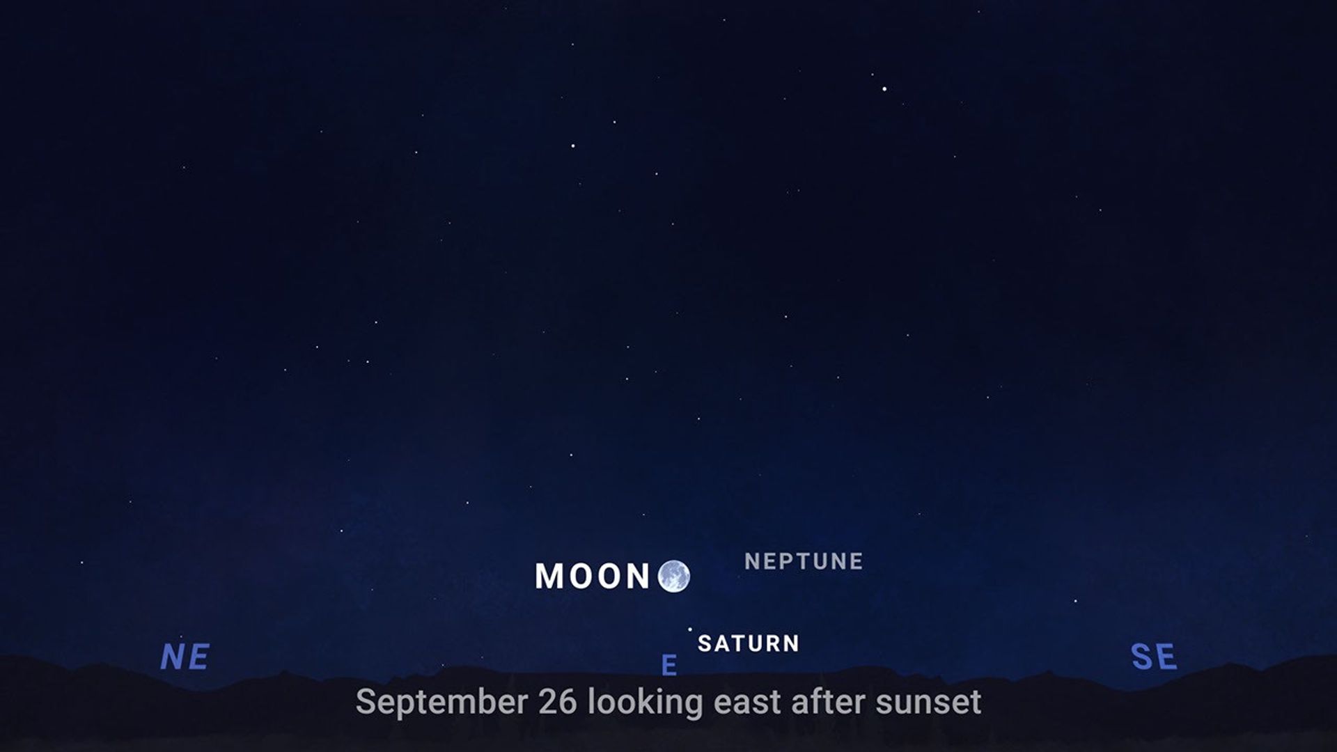
A sky chart looking east after sunset on Sept. 26, 2026.
NASA/JPL-Caltech

And on September 26, the Harvest Moon takes center stage, rising in the east shortly after sunset.

It won’t be alone. Saturn appears nearby, with faint Neptune completing a wide triangle in the sky.

Saturn is the easy one-you can see it with just your eyes. Neptune is a bit more challenging. At around magnitude 8, it’s too faint to see with the unaided eye …so you’ll need binoculars or a telescope to spot it. Darker skies and good observing conditions can help bring it into view.

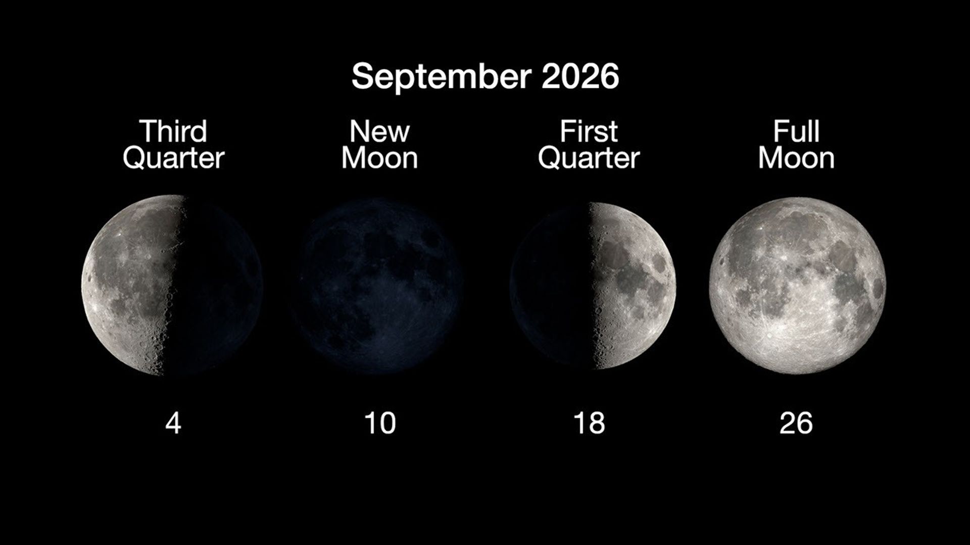
Here are the phases of the Moon for September.

The phases of the Moon for September 2026.
NASA/JPL-Caltech

You can stay up to date on all of NASA’s missions exploring the solar system and beyond at NASA Science. I’m Raquel Villanueva from NASA’s Jet Propulsion Laboratory, and that’s What’s Up this month.

Source: science.nasa.gov

Historic Engines Take Their Place on Artemis III

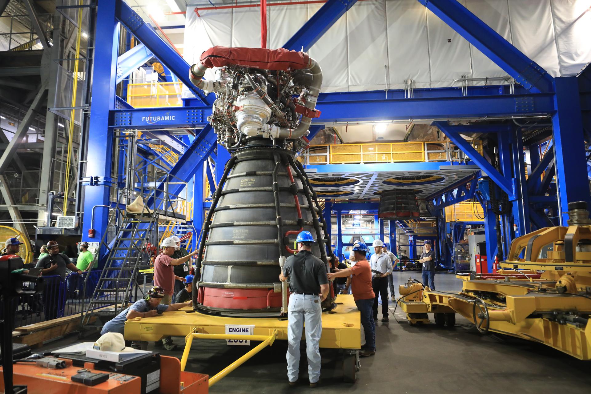
A rocket engine sits on a yellow transport platform inside a large industrial facility. Several technicians wearing hard hats and safety gear stand around the engine, inspecting and guiding it. The engine’s bell nozzle faces downward, and complex piping and hardware are visible at the top. Bright blue structural frames and elevated yellow walkways surround the work area, with additional equipment and machinery in the background.
NASA/Clayton Rougelot

On Aug. 24, technicians at NASA’s Kennedy Space Center in Florida began installing the four RS‑25 engines in the core stage of the agency’s Space Launch System (SLS) rocket that will carry the Artemis III crew into low Earth orbit in 2027.

Each RS‑25 engine has a unique serial number that records its detailed flight history. The four engines assigned to Artemis III — E2054, E2057, E2048, and E2052 — previously powered multiple space shuttle missions. Engine 2048 helped launch NASA astronaut Randy Bresnik’s earlier mission aboard space shuttle Atlantis during STS‑129. It also flew on Space Shuttle Discovery during STS‑95 in 1998, the mission that returned 77-year‑old space pioneer U.S. Sen. John Glenn to orbit, making him the oldest person to fly in space at that time.

Source: www.nasa.gov

APOD: 2026 September 1 – A Plane Lunar Eclipse

APOD

Astronomy Picture of the Day

Discover the cosmos! Each day a different image or photograph of our fascinating universe is featured, along with a brief explanation written by a professional astronomer.

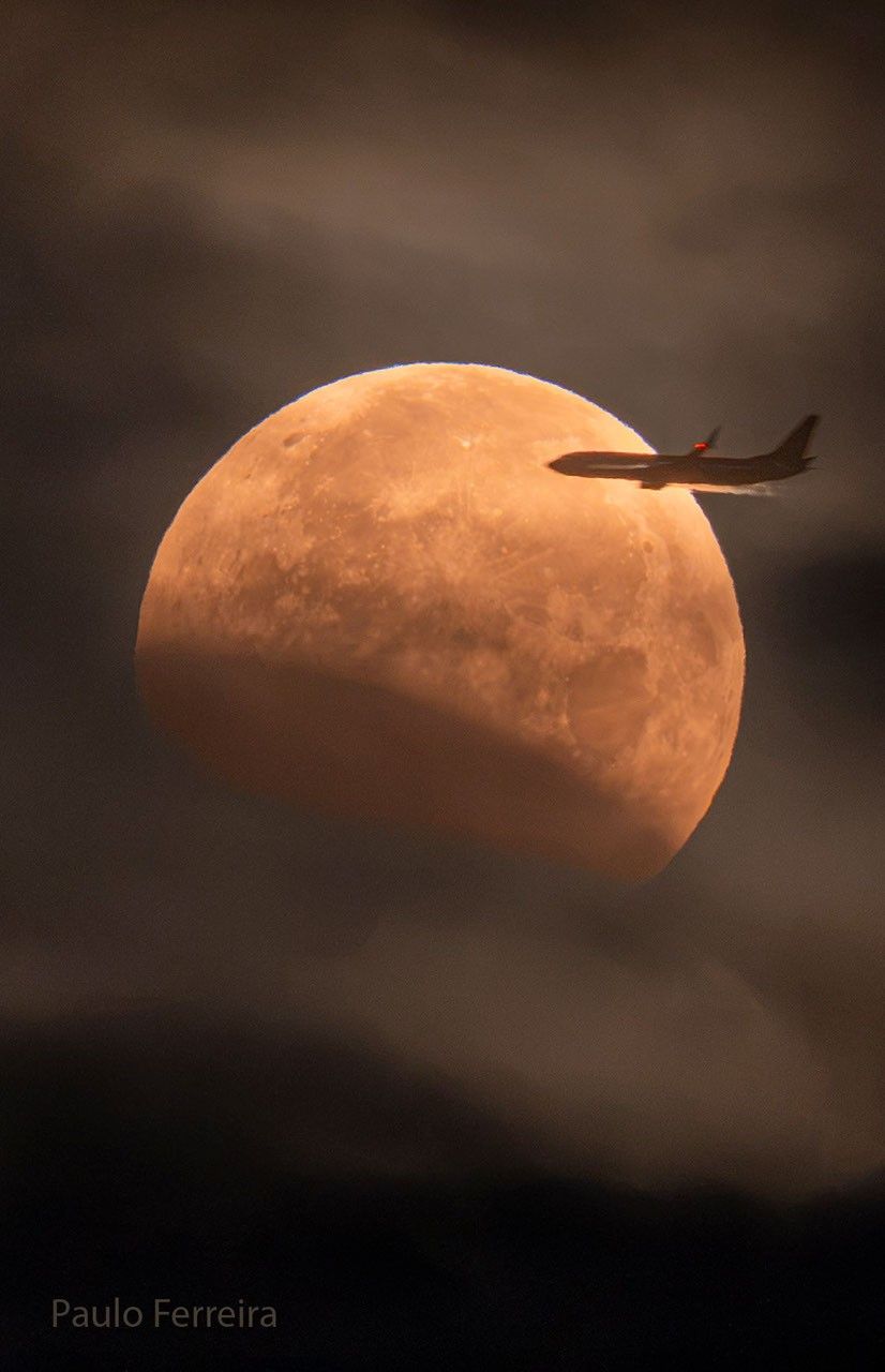
The Moon is seen in front of clouds but with part of its lower left being unusually dark. On the upper  right, a foreground airplane appears flying into the disk of the Moon.

A Plane Lunar Eclipse

Explanation: Did you need to be on the right side of this airplane to see this eclipse? No. Lunar eclipses are routinely seen from the half of the Earth facing the Moon when the eclipse occurs, making them some of the most commonly witnessed astronomical events. You don’t even need any special equipment to see one — just your unaided eyes. Lunar eclipses are also some of the most photographed astronomical events because, unlike with a solar eclipse, your eyes and camera do not have to look toward the bright Sun. However, considering the featured image taken last week from Portugal, if you were on the left side of that airplane during takeoff, you might have trouble seeing it — at first. But even then, after takeoff, since lunar eclipses typically last for hours, you might soon be able to safely cross the aisle(s) to see it.

Gallery: Lunar Eclipse of 2026 August
APOD’s main NASA site is moving: From apod.nasa.gov to science.nasa.gov/apod
Tomorrow’s picture: cultural eclipses

Date September 1, 2026
Credit Paulo Ferreira
Authors & editors: Robert Nemiroff, Jerry Bonnell, Cecilia Chirenti, Keighley Rockcliffe
A service of: ASD at NASA / GSFC,
NASA Science Activation & Michigan Tech. U.

Source: science.nasa.gov

Ice Island Survives Run-In With Joe Island


AUGUST 24
AUGUST 23

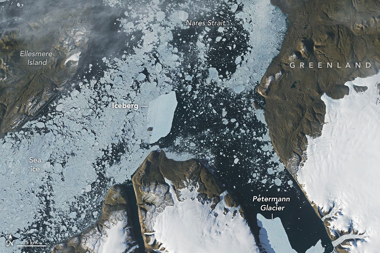
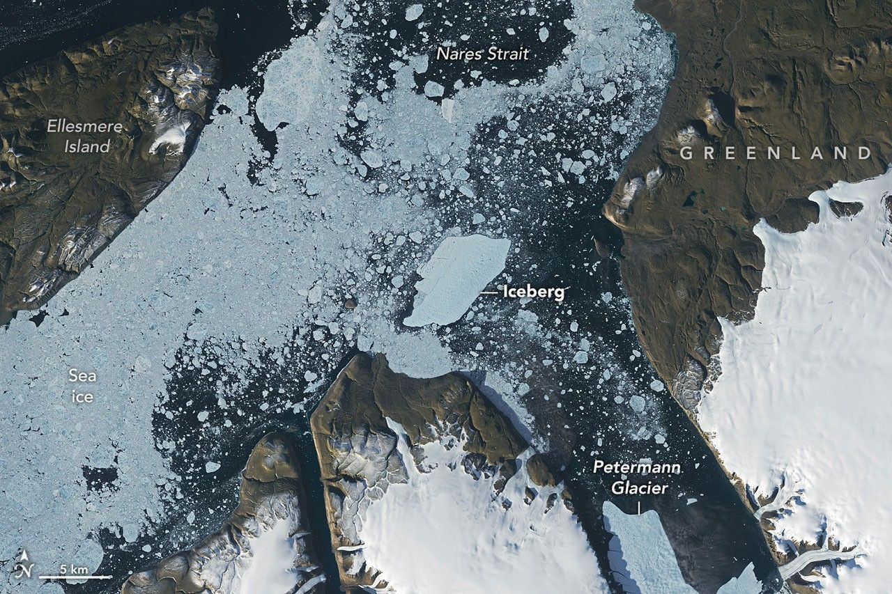
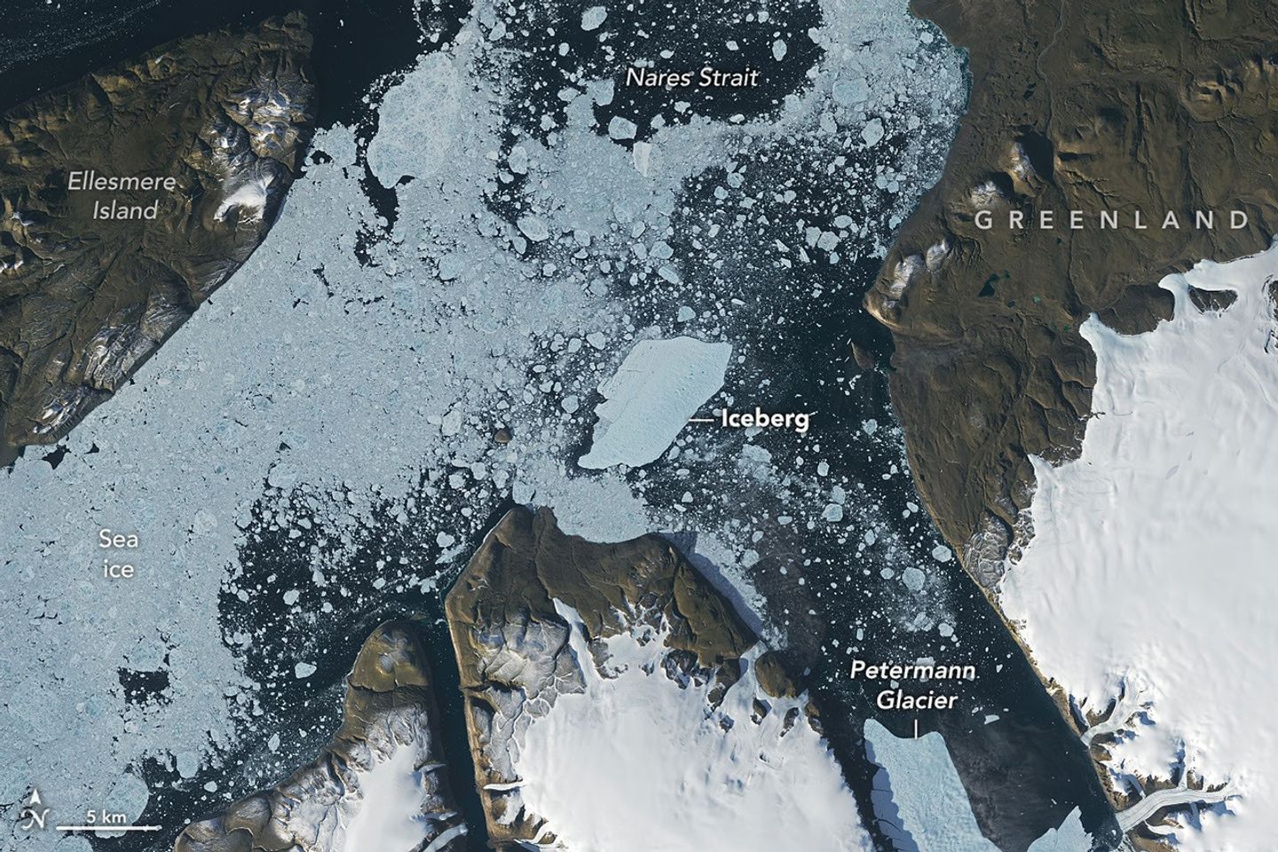
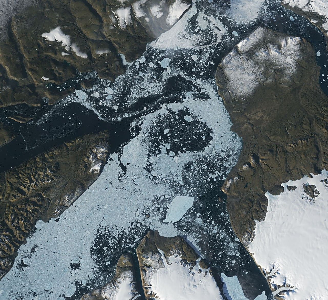
A satellite view shows the iceberg after it pivoted out of the fjord into Nares Strait, wedged against a small, brown island.
NASA Earth Observatory / Lauren Dauphin

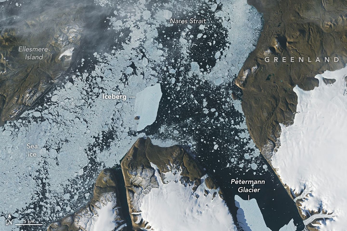
A satellite view shows a large tabular iceberg at the junction of its home fjord and Nares Strait.
NASA Earth Observatory / Lauren Dauphin


AUGUST 24

AUGUST 23


An iceberg from Petermann Glacier encounters Joe Island in northwestern Greenland, visible in images captured by the OLI (Operational Land Imager) on Landsat 9 on August 23, 2026 (right), and August 24, 2026 (left). NASA Earth Observatory images by Lauren Dauphin.

Summer is prime iceberg season in Greenland’s glacier-fed fjords, and 2026 was no exception. Especially notable was the berg that broke from the Petermann Glacier along Greenland’s northwest coast in August. Roughly the size of St. Thomas in the U.S. Virgin Islands, it was the largest calving event by any Arctic glacier since 2020.

Iceberg calving is a routine part of an outlet glacier’s life cycle. Scientists watch the process closely, however, along with numerous other observations of the ice and its environment, for longer-term signs of instability. Petermann is one of Greenland’s largest marine-terminating glaciers and acts as a gatekeeper for ice flowing from the ice sheet into the ocean. Its future stability has implications for sea level rise.

The calving event of summer 2026 was spotted on August 4 by Adam Garbo, a doctoral student in glaciology at the University of Ottawa, in imagery from the European Space Agency’s Sentinel-1 mission. Garbo and an international team of colleagues have been using remote sensing to study and track the glacier’s ice tongue.

The team reported that the large tabular iceberg, or “ice island,” measured just over 76 square kilometers (29 square miles) at the time it calved—the largest to break from the glacier since the ice island of 2012 (130 square kilometers). The 2012 calving followed earlier major events in 2008 (31 square kilometers) and 2010 (just over 250 square kilometers).

The August 2026 event could have been even bigger. Garbo and colleagues had been expecting a major calving once one of the large rifts they were monitoring finally cut all the way across Petermann’s ice tongue. “What surprised us was that the calving instead followed a different fracture, producing a smaller ice island than we had originally anticipated,” Garbo said. As of late August, two large rifts remained and were expected to eventually produce new ice islands of roughly 94 square kilometers and 84 square kilometers, though the timing remained uncertain.

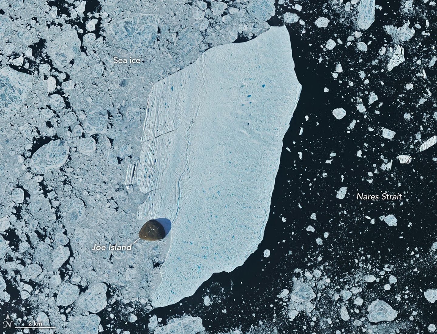
A detailed satellite view shows the iceberg wedged against the small, brown island, with sea ice packed densely to its left and more sparsely to its right.
August 24, 2026
NASA Earth Observatory/Lauren Dauphin

Glaciologist Mauri Pelto of Nichols College has also been tracking the iceberg, using images from NASA-USGS Landsat satellites, as it drifted down Petermann Fjord toward Nares Strait. In the week since it calved, the berg drifted an average of 3 kilometers per day. It continued toward the fjord’s junction with Nares Strait, where it rammed into a small rocky outcrop known as Joe Island (Joe Ø). The brief encounter is visible in images captured by the OLI (Operational Land Imager) on Landsat 9 on August 23 (top right) and August 24 (top left). A detailed view of the August 24 image is shown above.

Joe Island sits at the mouth of Petermann Fjord, making it one of the first obstacles a departing ice island meets. Collisions with it—like the one that split the 2010 ice island in two—often mark the start of a berg’s breakup. Petermann bergs tend to be thinner and more fragile than those calved by glaciers such as Greenland’s Jakobshavn and Helheim, and thinner still than Antarctica’s behemoths, Pelto noted.

“We were certainly watching closely as it interacted with Joe Island and were impressed that it survived the interaction without further fragmentation,” Garbo said.

The ice island was estimated to be less than 150 meters thick at the time of calving. Wind and surface currents have swept it out of the fjord, and satellite images show it pivoting away from Joe Island and continuing southwest through Nares Strait. As it drifts, it will fracture into smaller pieces as tides, winds, currents, and melting continue to weaken the ice.

Thicker bergs that calve from tidewater glaciers without floating ice-shelf extensions can drag and even become grounded on the seafloor within the fjord, while ice islands, like those from Petermann, might run aground later in their drift. Many ice islands have become “grounded” off the coasts of Coburg and Baffin islands.

Garbo and colleagues noted that ice islands and their fragments have been known to travel considerable distances, posing potential hazards to marine activities and infrastructure while also distributing freshwater through the ocean as they melt.

NASA Earth Observatory images by Lauren Dauphin, using Landsat data from the U.S. Geological Survey. Story by Kathryn Hansen.

References & Resources

You may also be interested in:

Stay up-to-date with the latest content from NASA as we explore the universe and discover more about our home planet.

Record-Setting Retreat of Hektoria Glacier

5 min read

Scientists relied on satellite data to understand how the Antarctic glacier lost so much ice so rapidly.

Article

Pasterze Hangs on as Austria’s Largest Glacier

4 min read

One narrowing icefall remains the linchpin for the Alpine glacier—and it may not be long for this world.

Article

An Uncommon Drifter in the Denmark Strait

4 min read

A large iceberg, observed in summer 2026, had drifted more than 1,000 kilometers south from the northeastern Greenland bay where…

Article

Source: science.nasa.gov

NASA Welcomes Türkiye as Newest Artemis Accords Signatory  

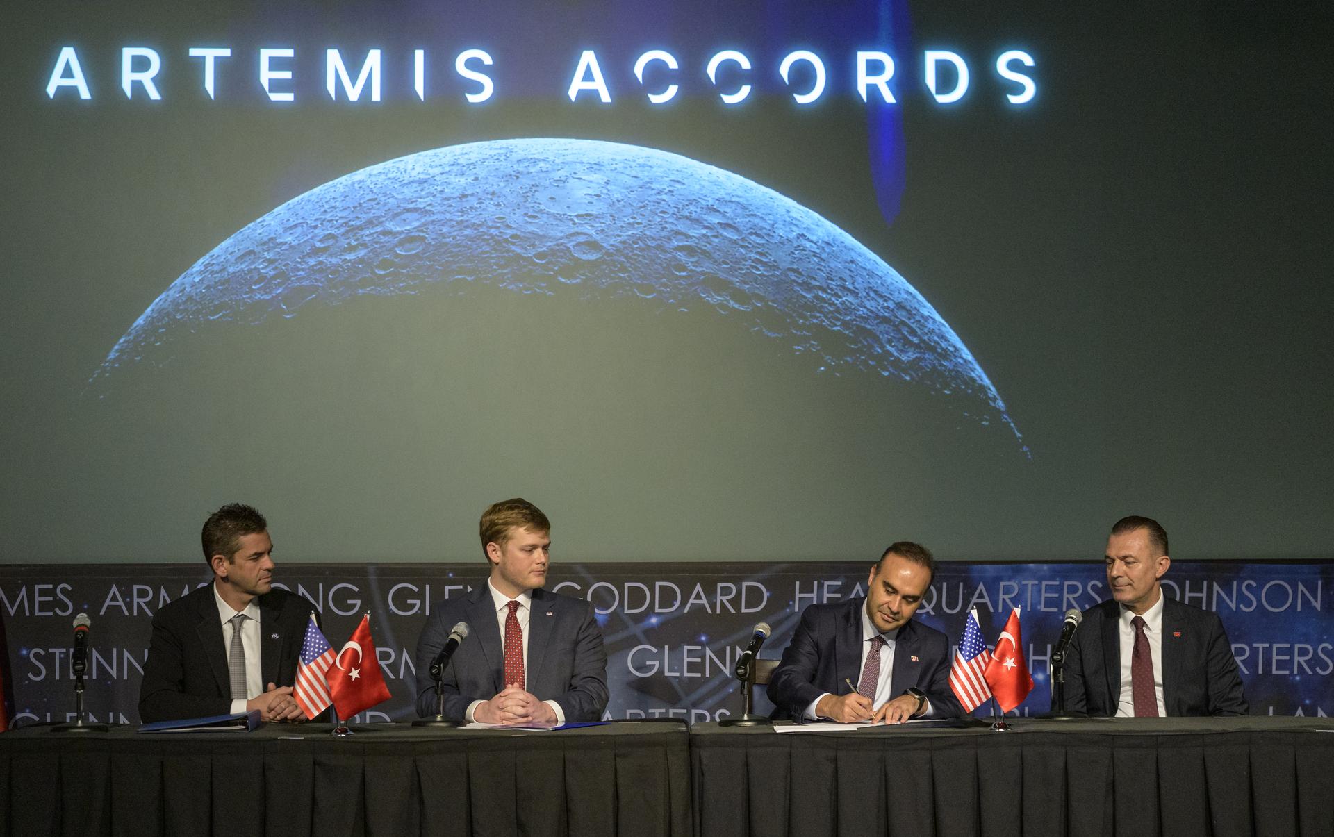
Turkish Minister of Industry and Technology, Mehmet Fatih Kacır, 3rd from left, signs the Artemis Accords for the Republic of Türkiye as NASA Administrator Jared Isaacman, left, U.S. Deputy Assistant Secretary of State for Space and Environment Connor Tomlinson, and Turkish Space Agency President, Yusuf Kıraç, right, look on, Monday, August 31, 2026, at the Mary W. Jackson NASA Headquarters building in Washington. Türkiye is the 71st country to sign the Artemis Accords, which establish a practical set of principles to guide space exploration cooperation among nations participating in NASA’s Artemis program.
Turkish Minister of Industry and Technology, Mehmet Fatih Kacır, 3rd from left, signs the Artemis Accords for the Republic of Türkiye as NASA Administrator Jared Isaacman, left, U.S. Deputy Assistant Secretary of State for Space and Environment Connor Tomlinson, and Turkish Space Agency President, Yusuf Kıraç, right, look on, Monday, August 31, 2026, at the Mary W. Jackson NASA Headquarters building in Washington.
NASA/Bill Ingalls

During a ceremony hosted by NASA Administrator Jared Isaacman at the agency’s headquarters in Washington on Monday, the Republic of Türkiye signed the Artemis Accords, joining the growing international coalition of like-minded nations dedicated to peaceful, transparent space exploration.

“It is my privilege to welcome the Republic of Türkiye as the 71st signatory of the Artemis Accords,” said Isaacman. “Last year, President Trump directed NASA to accelerate its return to the lunar surface and establish humanity’s first enduring presence on another world, a Moon Base, as well as lay the foundation for the manned exploration of Mars. NASA never undertakes these grand endeavors alone. On the Moon Base, we’re taking the Artemis Accords principles and putting them into practice on the lunar surface. NASA has invited every signatory to take part in this endeavor, creating opportunities for nations to contribute major pieces of hardware, scientific payloads, technology demonstrations, CubeSats, and other capabilities to future Artemis missions.”

Turkish Minister of Industry and Technology Mehmet Fatih Kacır signed on behalf of Türkiye. The President of the Turkish Space Agency Yusuf Kıraç, and the U.S. Deputy Assistant Secretary of State for Space and Environment Connor Tomlinson, also participated in the event.

Türkiye’s recent achievements in human spaceflight underscore its commitment to space exploration. In 2024, the country’s first astronaut, Alper Gezervaci, traveled to the International Space Station on Axiom Mission 3 and conducted scientific research alongside NASA astronauts. That same year, a second Turkish astronaut, Tuva Atasever, flew on Virgin Galactic 07 suborbital mission, conducting experiments and physiology research.

Türkiye will soon launch its first lunar mission, AYAP-1, joining the small but growing group of countries building and launching their own satellites to the Moon.

The country’s signing also comes as the country prepares to host the International Astronautical Congress in Antalya this October. Dozens of Artemis Accords signatories are expected to attend to discuss the future of peaceful and transparent space exploration.

In 2020, NASA and the State Department joined with seven other founding nations to establish the Artemis Accords, responding to the growing interest in lunar activities by both governments and private companies. They introduced the first set of practical principles aimed at enhancing the safety and coordination between nations as they explore the Moon, Mars, and beyond, committing nations to:

  • explore peaceably and transparently
  • render aid to those in need
  • enable access to scientific data
  • ensure activities do not interfere with those of others
  • preserve historically significant sites and artifacts by developing best practices

By signing the Artemis Accords, nations open the door to opportunities for future lunar exploration with NASA, advancing humanity’s return to the Moon, and shaping the Golden Age of space exploration and innovation.

Learn more about the Artemis Accords at: 

https://www.nasa.gov/artemis-accords

-end-

Source: www.nasa.gov

September 2026 Satellite Puzzler

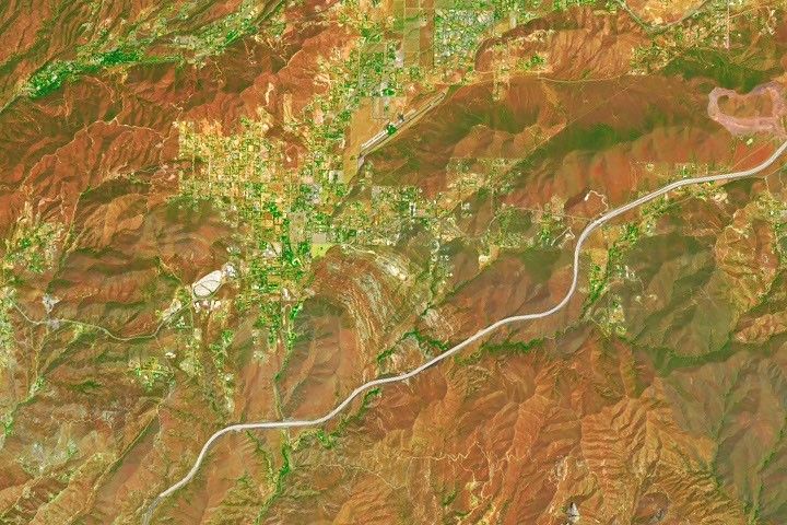
The image features a mixture of browns, greens, oranges, and yellows in both rectilinear and organic, curved shapes. A curving gray line runs diagonally through it.

Every month, NASA Earth Observatory features a puzzling satellite image. The September 2026 puzzler appears above. 

Your Challenge
I
dentify the location shown in this satellite image. Share what clues you see, where you think it is, and what makes this place interesting or unique to you.

How to Answer
Submit your response using this form and select “Puzzler Answer” as the topic. Please include your preferred name or alias.

You can keep it simple and just guess the location. Want to impress us? Tell us which satellite and instrument captured the image, which spectral bands were used, or point out a subtle detail about the geology or history of the area. If something catches your eye, or if this is your home or means something to you, we’d love to hear about it.

The Prize
We can’t offer prize money or a trip to space to see Earth like satellites and astronauts do. But we can offer something almost as rewarding: puzzler bragging rights.

About a week after the challenge, we’ll post the answer at the top of this page, along with a link to an Earth Observatory Image of the Day story that explains the image in more detail. We’ll recognize the first person who correctly guesses the location, and we may also highlight readers who share especially thoughtful or interesting answers. By submitting a response, you acknowledge that your comments may be edited, excerpted, and published on this page.

Until then, zoom in, look closely, and enjoy the challenge. See you at the reveal!

Source: science.nasa.gov
NASA’s Nancy Grace Roman Space Telescope Launches

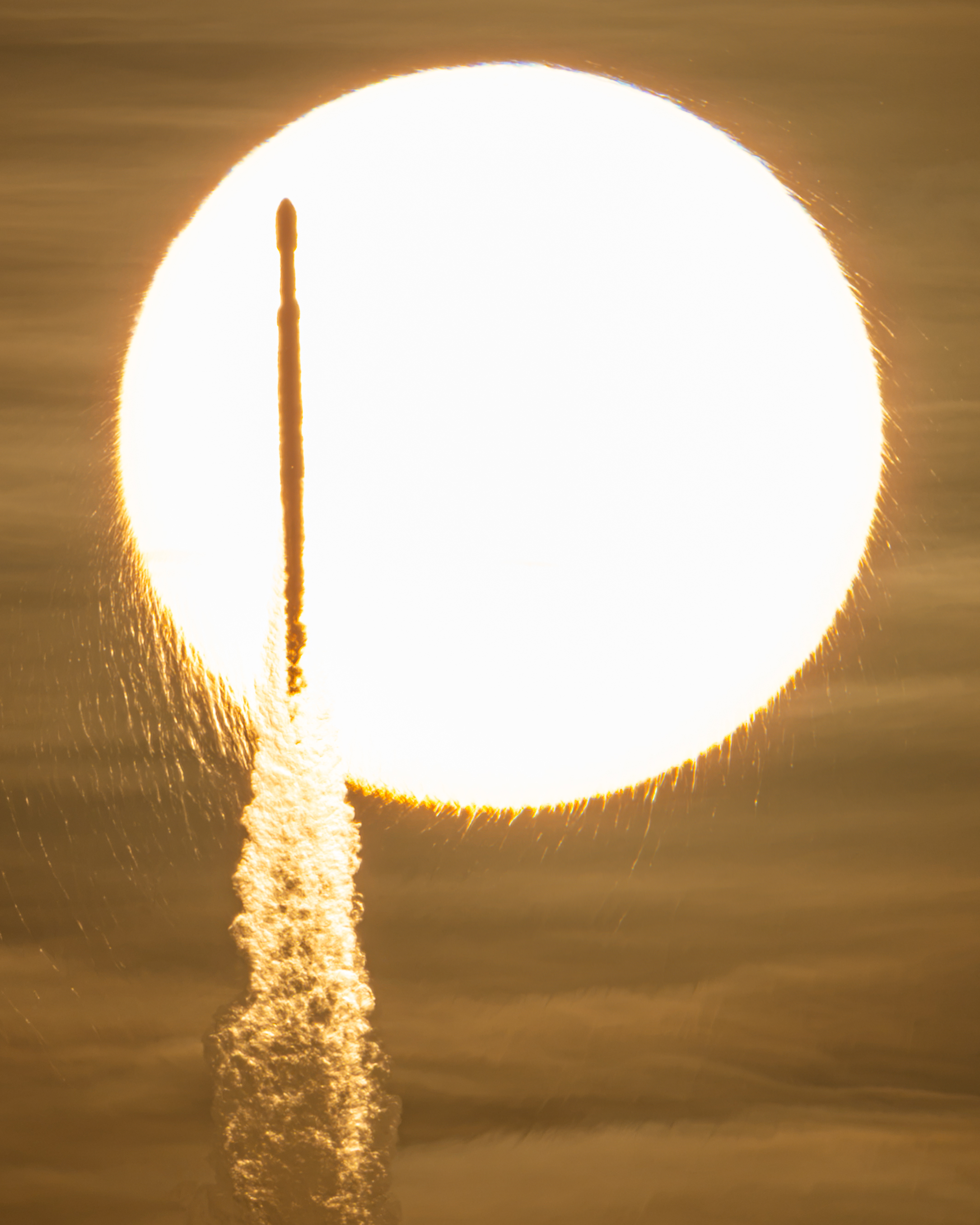
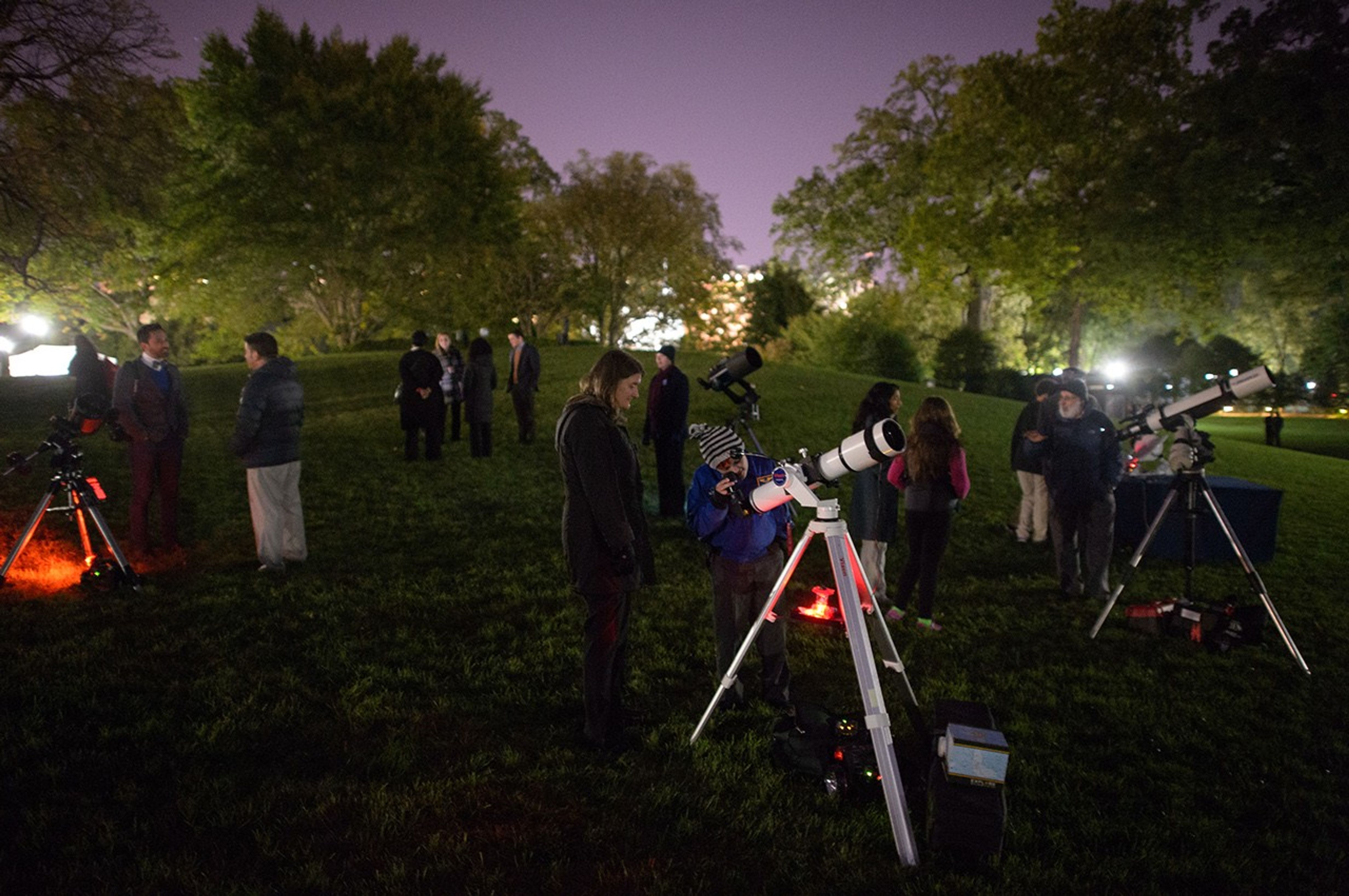
In a sepia-toned photo, the Sun appears as a bright, enormous orb that appears to have frayed edges. Against this backdrop, a tall and slender rocket is seen in silhouette atop a cloudy plume.
NASA/John Kraus

NASA’s Nancy Grace Roman Space Telescope, aboard a SpaceX Falcon Heavy rocket, transits the Sun during launch from the agency’s Kennedy Space Center in Florida on Aug. 30, 2026. Roman is named after the agency’s first chief astronomer.

Roman will survey billions of stars and galaxies with a field of view far larger than Hubble’s, helping scientists study dark energy, exoplanets, and the evolution of the universe.

Follow along with Roman’s journey.

Image credit: NASA/John Kraus

Source: www.nasa.gov

Roman Commissioning

2 Min Read

Roman Commissioning

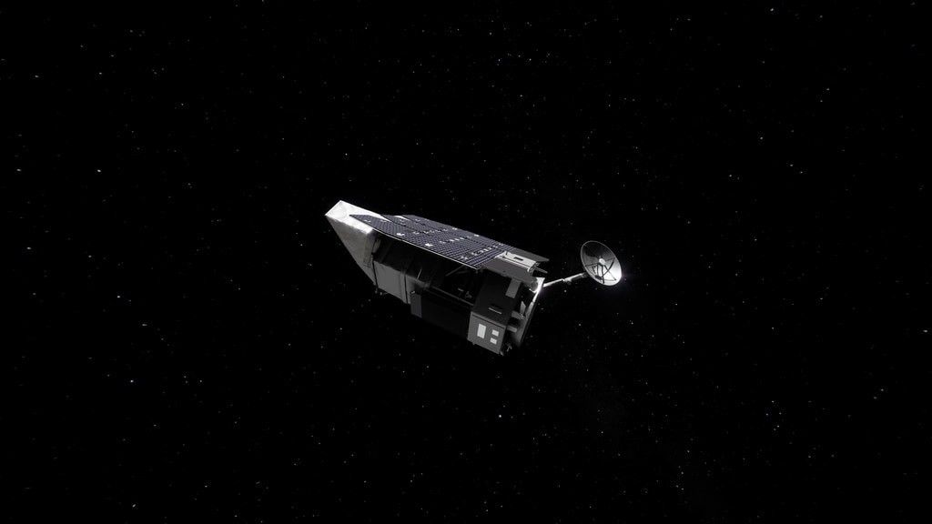
Beauty pass of Roman Space Telescope

Beauty pass of Roman, coming around from behind with high-gain antenna rotating.

Credits:
NASA’s Goddard Space Flight Center/Conceptual Image Lab

Where is Roman?

Roman is making its three-month journey from Earth to Sun-Earth Lagrange Point 2, or L2. Along the way, Roman is undergoing a process called commissioning, where systems are turned on, adjusted, calibrated, and prepared for science operations. Commissioning is the time for scientists and engineers to make sure that Roman is performing as expected. The schedule is subject to change as the team assesses and adjusts as needed.

Deployments

An hour and 23 minutes after launch, Roman began to emerge from the tight configuration that allowed it to fit in the rocket fairing. The solar panels and sunshade deployed, shading the rest of the observatory and providing power to the systems. Within the upcoming days, the antenna will swing out and the visor-like deployable aperture cover will move into place to permanently reveal and shade the primary mirror.

Roman’s Orbit

This visualization shows the stable, halo orbit that Roman will have around L2. At this location, the gravity of the Sun and Earth, together with an object’s motion around the Sun, let it stay lined up with Earth as they orbit, allowing Roman to have a relatively steady orbit without using much fuel. This location also offers exceptionally stable optical performance and a constant, unobstructed view of a wide swath of the sky; Earth won’t block much of Roman’s view since it will be so distant. And at L2, heat from Earth, the Sun, and the Moon have less effect on infrared telescopes, which “see” heat.

Unable to render the provided source

Explore the Roman Systems

Learn more about the systems that are getting turned on, tested and calibrated.

Unable to render the provided source

3D View


Source: science.nasa.gov
APOD: 2026 August 31 – Launch of the Roman Space Telescope

APOD

Astronomy Picture of the Day

Discover the cosmos! Each day a different image or photograph of our fascinating universe is featured, along with a brief explanation written by a professional astronomer.

Launch of the Roman Space Telescope

Explanation: A new telescope has been launched into space to study the universe. The Nancy Grace Roman Space Telescope (RST) has the same size main mirror as the Hubble Space Telescope (HST) but sees 100 times more sky during each snapshot. This is possible because when compared to HST, RST’s main mirror is more curved, its secondary mirror is closer, and its main camera is larger. The result is that RST can inspect more of the sky more quickly, likely allowing, among other capabilities, the discovery of many more supernovas which tell us more about the expansion rate and composition of our universe, and many more planets orbiting other stars that tell us more about the possibilities for life elsewhere in the universe. RST will orbit the Sun, not the Earth, like the James Webb Space Telescope. The featured video shows Roman being launched yesterday from Kennedy Space Center, Florida, USA aboard a SpaceX Falcon Heavy rocket.

APOD’s main NASA site is moving: From apod.nasa.gov to science.nasa.gov/apod
Tomorrow’s picture: eclipse flight

Date August 31, 2026
Credit: NASA
Authors & editors: Robert Nemiroff, Jerry Bonnell, Cecilia Chirenti, Keighley Rockcliffe
A service of: ASD at NASA / GSFC,
NASA Science Activation & Michigan Tech. U.

Source: science.nasa.gov