NASA Adds Blue Origin New Glenn 9×4 to Launch Services Contract

NASA meatball
Credit: NASA

In accordance with a contract on-ramp clause, NASA has added Blue Origin’s New Glenn 9×4 launch service to the NASA Launch Services (NLS) II contract. The New Glenn 9×4 launch service will be available to NASA’s Launch Services Program Office to use for future missions.

The NLS II contracts are multiple-award, indefinite-delivery/indefinite-quantity contracts with an ordering period through June 2030, and an overall period of performance through December 2032. The NLS II contracts include an on-ramp provision that provides an opportunity annually for new launch service providers to compete for future missions and allows existing contractors to introduce launch vehicles not currently on their NLS II contracts.

The NLS II contracts support the goals and objectives of the agency’s Human Spaceflight Mission Directorate, Science Mission Directorate, and the Research and Technology Mission Directorate. Under the contract, NASA also can provide launch services to other government agencies, such as the National Oceanic and Atmospheric Administration.

NASA’s Launch Services Program Office at the agency’s Kennedy Space Center in Florida manages the NLS II contracts. For more information about NASA visit:

https://www.nasa.gov

-end-

Joshua Finch / Jimi Russell
Headquarters, Washington
202-358-1100
[email protected] / [email protected]

Leejay Lockhart
Kennedy Space Center, Fla.
321-747-8310
[email protected]

Details

Last Updated

Sep 29, 2026

Editor
Jennifer M. Dooren

Source: www.nasa.gov

NASA Features Exploration, Science at International Space Conference 

Caption: Broadway performers are seen as they sing during the opening ceremony of the 70th International Astronautical Congress, Oct. 21, 2019 at the Walter E. Washington Convention Center in Washington.
Credit: NASA/Joel Kowsky

NASA will participate in the 77th International Astronautical Congress (IAC) in Antalya, Türkiye, from Monday, Oct. 5, to Friday, Oct. 9, highlighting America’s leadership in human exploration to the Moon and Mars, advancing responsible exploration under the Artemis Accords, world-changing science, and support for the commercial space sector. 

The IAC, organized by the International Astronautical Federation, is hosted this year by the Turkish Space Agency (TUA). 

The NASA delegation, led by NASA Deputy Administrator Matt Anderson, will take part in plenary sessions, technical discussions, and media engagements throughout the week. 

Monday, Oct. 5  

  • 3 a.m. EDT (10 a.m. TRT): “One-to-One with Heads of Space Agencies” featuring Anderson  
  • 9:30 a.m. EDT (4:30 p.m. TRT): “Transforming the Speed of Science with a New Model for Earth Observation Cooperation: International and Commercial Fleets with More Rapid Mission Development” with keynote speaker Karen St. Germain, division director, Earth Science Division, NASA’s Science Mission Directorate 

Tuesday, Oct. 6 

  • 4:45 a.m. EDT (11:45 a.m. TRT): “Artemis II Mission Results: The Industry Perspective” featuring Jeremy Parsons, Artemis program manager, NASA’s Human Spaceflight Mission Directorate 

Wednesday, Oct. 7  

  • 3:15 a.m. EDT (10:15 a.m. TRT): “Space Manufacturing Technology: Driving the Next Revolution in Biotechnology, Advanced Materials, and Human Exploration” featuring Fathi Karouia, senior research scientist, Blue Marble Space Institute of Science, exobiology branch, NASA’s Ames Research Center in California’s Silicon Valley 
  • 4:35 a.m. EDT (11:35 a.m. TRT): “From Observation to Decision – Cracking the Last Mile Challenge” with St. Germain  
  • 5 a.m. EDT (12 p.m. TRT): Artemis Accords news conference with Anderson and Major General Roberto Melgar Sheen, director of the Peruvian Space Agency (CONIDA) 
  • 8 a.m. EDT (3 p.m. TRT): “Trusted AI on Mars” featuring Steve Chien, technical fellow and senior research scientist in the Artificial Intelligence Group at NASA’s Jet Propulsion Laboratory in Southern California 
  • 9:35 a.m. EDT (4:35 p.m. TRT): “NASA’s Artemis II Preliminary Lunar Science Release” featuring Anderson, Dr. Lori Glaze, associate administrator, NASA’s Human Spaceflight Mission Directorate, Dr. Nicky Fox, associate administrator, NASA’s Science Mission Directorate, and Dr. Kelsey Young, Artemis II lunar science lead, NASA’s Science Mission Directorate 

Thursday, Oct. 8  

  • 10:45 a.m. EDT (5:45 p.m. TRT): “Pioneering Organ-Chip Research in Space to Advance Precision Health” featuring Dr. Lisa Carnell, division director, Biological and Physical Sciences, NASA’s Science Mission Directorate  

Friday, Oct. 9 

  • 3 a.m. EDT (10 a.m. TRT): “What It’s Like to Be an Astronaut” with NASA astronaut Chris Williams at NASA’s exhibit

How to Attend/Watch 

A full agenda for this year’s IAC is available online for registered media. To view select events, visit the International Astronautical Federation YouTube channel.  

In addition to the events outlined above, NASA will have an exhibit featuring the agency’s contributions to space exploration, celebrating the U.S. Freedom 250 commemoration, and U.S. leadership in space exploration, science, and technological innovation.

NASA’s exhibit booth number is in Hall 1 at NEST Convention Centre. 

To learn more about NASA international partnerships, visit:

https://www.nasa.gov/oiir

-end-

George Alderman / Elizabeth Shaw  
Headquarters, Washington 
202-358-1600 
[email protected] / [email protected]

Source: www.nasa.gov

NASA Awards Orbital Safety Analysis Support Services Contract

NASA has awarded a contract to Omitron Inc. for the acquisition of orbital safety analysis services, which provide for critical protection of NASA spaceflight assets and astronaut lives.

This indefinite-delivery contract is valued at approximately $23.5 million over a five-year period of performance and entails conjunction assessment screening services for all NASA uncrewed spacecraft, support of human spaceflight activities, and orbital safety analysis support to the National Oceanic and Atmospheric Administration’s Office of Space Commerce.

The work will take place at Omitron’s location in Beltsville, Maryland, NASA’s Goddard Space Flight Center in Greenbelt, Maryland, the agency’s Johnson Space Center in Houston, Naval Surface Warfare Center Dahlgren in Virginia, and Peterson Space Force Base in Colorado Springs, Colorado.

For information about NASA and agency programs, please visit:

https://www.nasa.gov/

-end-

Robert Garner
Goddard Space Flight Center, Greenbelt, Md.
301-286-5687
[email protected]

Details

Last Updated

Sep 29, 2026

Editor
Rob Garner
Contact
Rob Garner
Location
Goddard Space Flight Center

Source: www.nasa.gov

NASA Opens 2027 Human Lander Challenge for Lunar Communications

3 min read

Preparations for Next Moonwalk Simulations Underway (and Underwater)

Banner image for 2027 Human Lander Challenge.
NASA

NASA’s 2027 Human Lander Challenge is seeking ideas from college and university students to help address one of the most critical needs for sustained lunar exploration: reliable communications.

As NASA prepares for long-term human presence on the Moon through the Artemis and Moon Base programs, communications systems will be just as important as spacecraft and rockets. A resilient communications system will connect astronauts, rovers, habitats, landers, mission support teams on Earth, and more. Reliable communications are essential for ensuring safety, coordinating complex operations, and enabling timely decision-making in the harsh and remote lunar environment.

“Reliable communications will be at the heart of our ability to explore and operate on the Moon,” said Jeremy Del Greco, Human Landing System program communications integration lead at NASA’s Marshall Space Flight Center in Huntsville, Alabama. “As Artemis and Moon Base missions expand our presence beyond Earth, we will need dependable connections across the lunar surface and beyond. The 2027 Human Lander Challenge gives students the opportunity to help shape the communications capabilities of tomorrow and support future lunar exploration.”

The 2027 competition invites United States-based collegiate teams and their faculty advisers to develop innovative, systems-level solutions to better understand, establish, and optimize lunar communications for landers and surface operations that can be implemented within three to five years.

Teams should submit a non-binding notice of intent by Thursday, Oct. 15, if they would like to participate. Proposal packages, including a five to seven-page proposal and a two-minute video, are due March 4, 2027.

While teams may propose solutions outside of the focus areas, NASA has identified three main categories to advance future lunar communications capabilities:

  • Hardware:
    • Space-rated wireless networks and electronics
    • Antenna signal propagation, modeling, and environmental mitigation
  • Software:
    • Data efficiency and link optimization
    • Network management and scheduling
  • Architecture
    • Surface communications system architecture
    • Orbital communications system architecture

Based on proposal package evaluations in phase 1, up to 12 finalist teams will be selected to receive $9,000 and advance to phase 2 of the competition, which includes a final design review in Huntsville, Alabama, home of NASA’s Marshall Space Flight Center, June 21–24, 2027. The top three teams from phase 2 will share a total prize of $18,000.

The Human Lander Challenge is administered by the National Institute of Aerospace on behalf of the agency and supports NASA’s efforts to foster innovative solutions to a variety of areas for long-duration human spaceflight plans at the Moon. The Human Lander Challenge is sponsored by the agency’s Human Spaceflight Mission Directorate’s Human Landing System Program Office.

Through the Artemis program, NASA will send astronauts to explore the Moon for scientific discovery, economic benefits, and to build the foundation for the first crewed missions to Mars – for the benefit of all.

For more information on NASA’s Human Lander Challenge and how to participate, visit:

https://hulc.nianet.org/

Source: www.nasa.gov

APOD: 2026 September 30 – Arp 78: Peculiar Galaxy in Aries

APOD

Astronomy Picture of the Day

Discover the cosmos! Each day a different image or photograph of our fascinating universe is featured, along with a brief explanation written by a professional astronomer.

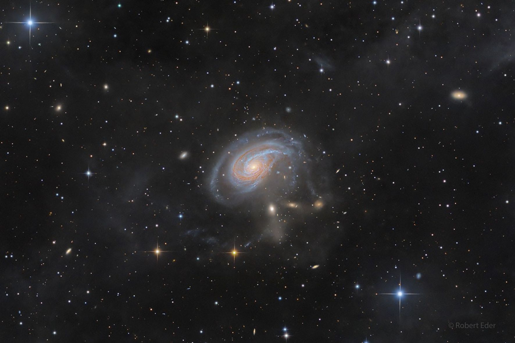
A spiral galaxy viewed face-on with an extended spiral arm.

Arp 78: Peculiar Galaxy in Aries

Explanation: Peculiar spiral galaxy Arp 78 is found within the boundaries of the head strong constellation Aries. Some 100 million light-years beyond the stars and nebulae of our Milky Way galaxy, the island universe is an enormous 200,000 light-years across. Also known as NGC 772, it sports a prominent, outer spiral arm in this detailed cosmic portrait. Tracking along sweeping dust lanes and lined with young blue star clusters, Arp 78’s overdeveloped spiral arm is pumped-up by galactic-scale gravitational tides. Interactions with its brightest companion galaxy, the more compact NGC 770 seen directly below the larger spiral, are likely responsible. Embedded in faint star streams revealed in the deep telescopic exposure, NGC 770’s fuzzy, elliptical appearance contrasts nicely with spiky foreground Milky Way stars.

APOD’s email for image submissions has changed. Please see: APOD Submissions.
Tomorrow’s picture: a harvest

Date September 30, 2026
Credit & Copyright Robert Eder
Authors & editors: Jerry Bonnell, Cecilia Chirenti, Robert Nemiroff, Keighley Rockcliffe
A service of: ASD at NASA / GSFC,
NASA Science Activation & Michigan Tech. U.

Source: science.nasa.gov

NASA, International Partners Advance Work on Space Crops

NASA, CSA (Canadian Space Agency), and the German Aerospace Center signed a joint statement of intent to begin coordinated, preparatory work toward an Earth-based demonstrator to learn how to grow crops on the Moon, which will be essential to helping astronauts go farther and stay longer in space.

The Lunar Agriculture Module-Ground Test Demonstrator aims to develop the technologies needed to grow space crops and study how they perform under atmospheres and controlled environments similar to those expected during missions at Moon Base. Through Moon Base, NASA and its partners will build the infrastructure to support an enduring human presence near the Moon’s South Pole, advancing science and technology while preparing for future human missions to Mars. Space crops will provide deep space crews with whole-food nutrition and increase dietary variety.  They can also absorb carbon dioxide, produce oxygen, and recycle water. These capabilities will become increasingly important as human missions extend farther from our home planet.

Horticulture scientist Blake Costine adjusts moisture sensors for the Advanced Plant Imaging project at NASA’s Kennedy Space Center on April 17, 2023. In this project, hyperspectral cameras are used to assess plant health. The activity is taking place inside the Plant Production Area at the Florida spaceport’s Space Station Processing Facility.
NASA/Isaac Watson

Source: science.nasa.gov

Uncovering the Valleys Hidden Below Greenland’s Ice

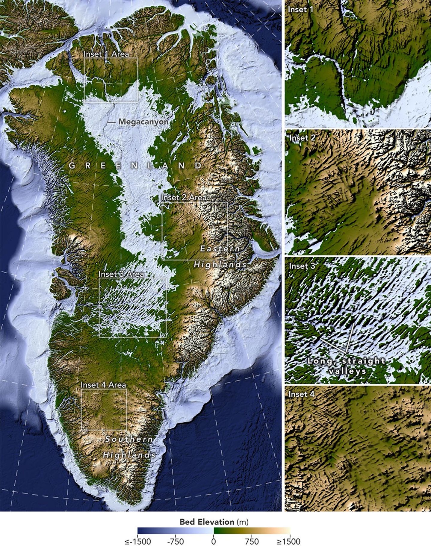
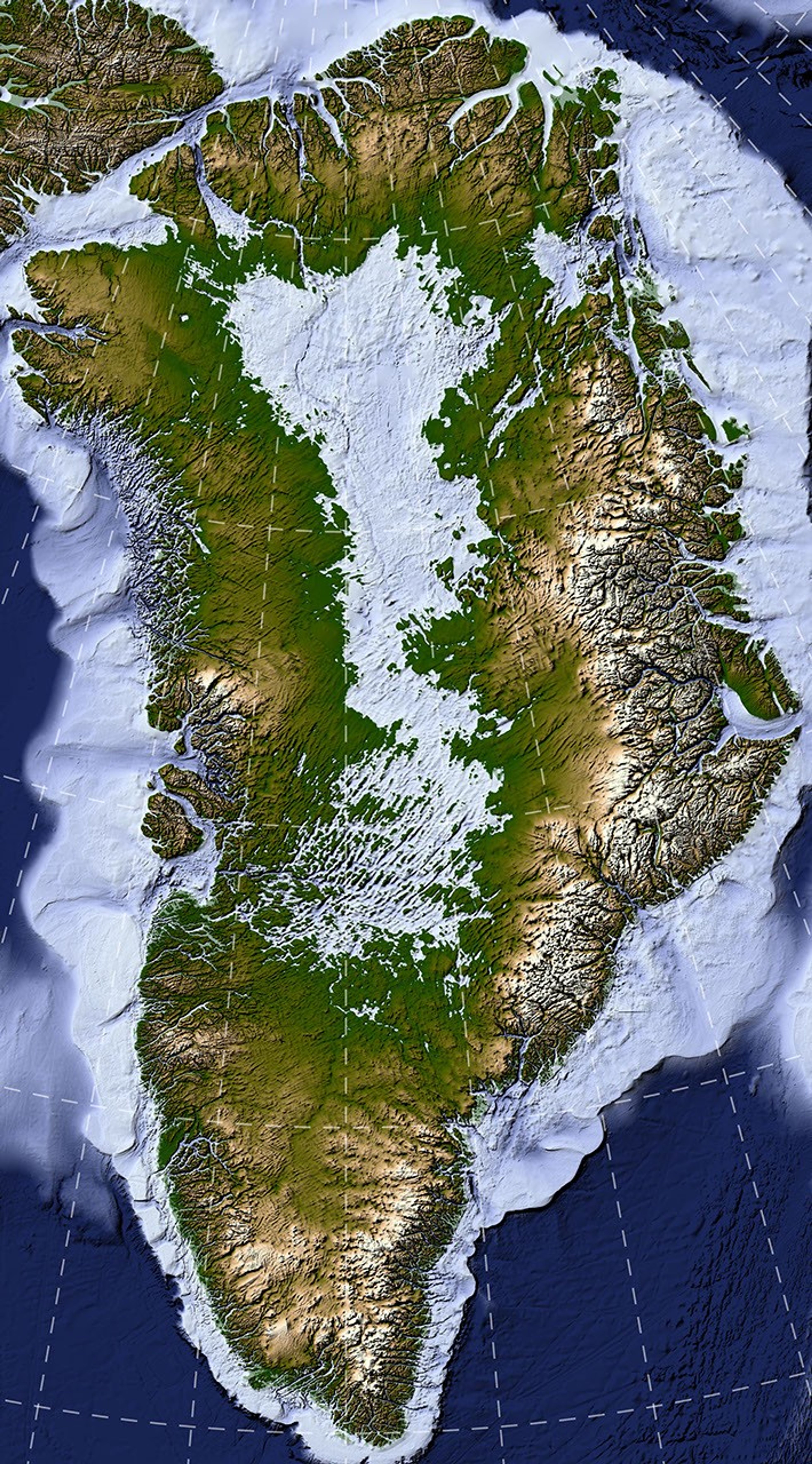
A large map on the left shows Greenland’s bedrock topography that lies below the ice sheet. A column of smaller maps on the right zooms in on several features, including long, straight valleys on the west-central part of the island. Other insets show a megacanyon, as well as valleys radiating outward from the highlands.
A newly developed method for mapping the bedrock beneath Greenland’s ice sheet reveals the island’s hidden topography. Among the most striking finds are long, straight valleys in the west-central region, some mapped for the first time and others extending farther inland than previously known (inset 3).
NASA Earth Observatory/Lauren Dauphin, based on data from Chartrand et al.

Greenland is capped with a vast ice sheet that spans 1.7 million square kilometers (656,000 square miles) and measures more than 3 kilometers (1.9 miles) at its thickest point. Below all this ice lies a landscape human eyes have never seen directly. But a newly developed method for mapping this hidden bedrock has produced the most detailed and accurate view of it yet.

The new map reveals an expansive network of valleys carved into the surface beneath the Greenland Ice Sheet. Many of the features formed well before most of the ice above them existed, offering new context for the island’s geologic history—and potentially helping scientists refine projections of the ice sheet’s future. Scientists described the newly mapped valleys in a NASA-led paper published in Geophysical Research Letters.

The map, shown above, was derived from a method called Ice Flow Perturbation Analysis. As ice flows over a valley or ridge, the topography leaves a faint signature on the ice surface. Satellites map the ice surface in fine detail, and scientists can use these subtle bumps and dips to infer the shape of the landscape buried below. The work aims to improve future versions of BedMachine Greenland, a high-resolution dataset of the terrain beneath the ice sheet.

Using the technique, researchers manually mapped 1,943 subglacial valleys beneath the Greenland Ice Sheet, about a third of which are newly identified. About half of the valleys included in BedMachine Greenland, primarily near the ice sheet’s edge, are now known to extend farther inland than that map indicates, in some cases by hundreds of kilometers.

Some aspects of the new map align with the current understanding of how Greenland’s landscapes formed. For instance, many of the valleys appear to begin in the southern and eastern highlands, where the ice sheet is thought to have first formed. Near the eastern highlands, the map reveals a mountain range beneath the ice, with interconnected valleys and relief that increases toward the coast. These alpine-style landforms may have survived under the ice since at least the Pliocene.

Other aspects of the topography are more puzzling. The analysis indicates numerous valleys, especially in the west-central region, that are long, straight, and consistently aligned in a southwest-northeast direction. This orientation suggests a tectonic influence, generating preferential pathways along which water could flow and valleys could form. “That’s a riddle to us,” said Joe MacGregor, a NASA cryospheric scientist and co-author of the study. “Greenland is justifiably usually treated as a rigid block of old rock that is simply translated as needed to accommodate the motion and interactions of other tectonic plates.”

Separately, the angles at which the valleys branch offer another insight into their origin. Their relatively wide branching angles suggest that surface water didn’t act alone; instead, a widespread groundwater network—seeping upward and eroding the surrounding rock—likely helped carve the valleys before the ice sheet formed.

Mapping these valleys matters for understanding the ice sheet, which has continued to dramatically reshape the landscape. Ice flow concentrates in valleys, where it forms glaciers that eventually calve into fjords at the periphery of the ice sheet. This creates a reinforcing cycle: ice funneling through a valley gets thicker, thicker ice flows faster, and faster flow carves the valley even deeper.

This carving power is especially evident along western Greenland. MacGregor likened it to the glacially incised landscape at Yosemite, with Greenland’s western coast resembling, as he put it, “El Capitan after El Capitan.”

Studying the valleys also matters for the ice sheet’s future. Because the relationship between ice flow and valleys is well understood, scientists expect that as the ice sheet retreats, flow will continue to concentrate wherever the valleys already are. “The better we understand the topography now,” MacGregor said, “the better sense we’ll have of what it will look like in the longer term—beyond the next decade or two—as faster ice flow propagates into Greenland’s interior.”

NASA Earth Observatory map by Lauren Dauphin using data from Chartrand et al. Story by Kathryn Hansen.

References & Resources

You may also be interested in:

Stay up-to-date with the latest content from NASA as we explore the universe and discover more about our home planet.

An Uncommon Drifter in the Denmark Strait

4 min read

A large iceberg, observed in summer 2026, had drifted more than 1,000 kilometers south from the northeastern Greenland bay where…

Article

A Bare Summer for Barnes Ice Cap

4 min read

The expanse of glacial ice on Canada’s Baffin Island lost its snow cover quickly and early in summer 2026, revealing…

Article

Pasterze Hangs on as Austria’s Largest Glacier

4 min read

One narrowing icefall remains the linchpin for the Alpine glacier—and it may not be long for this world.

Article

Source: science.nasa.gov

Powerful Storms Continue to Prowl the Pacific

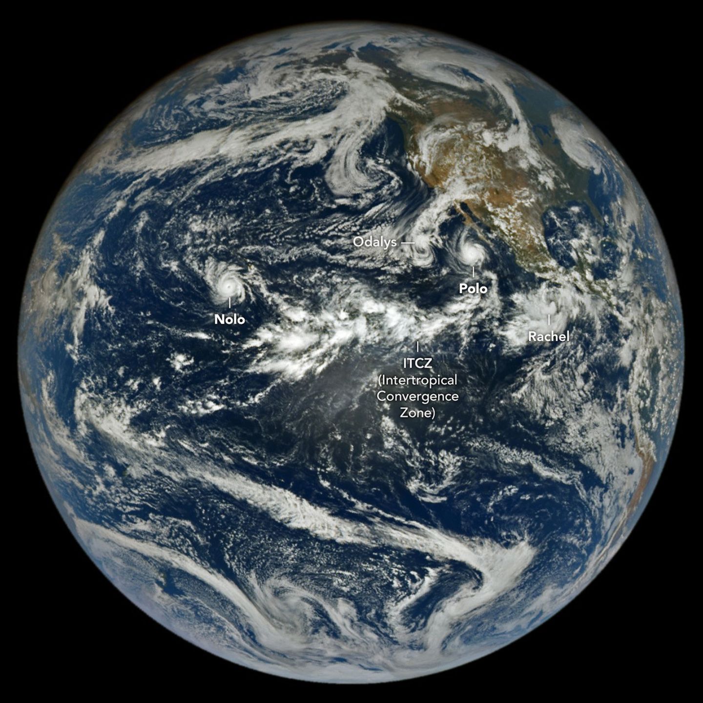
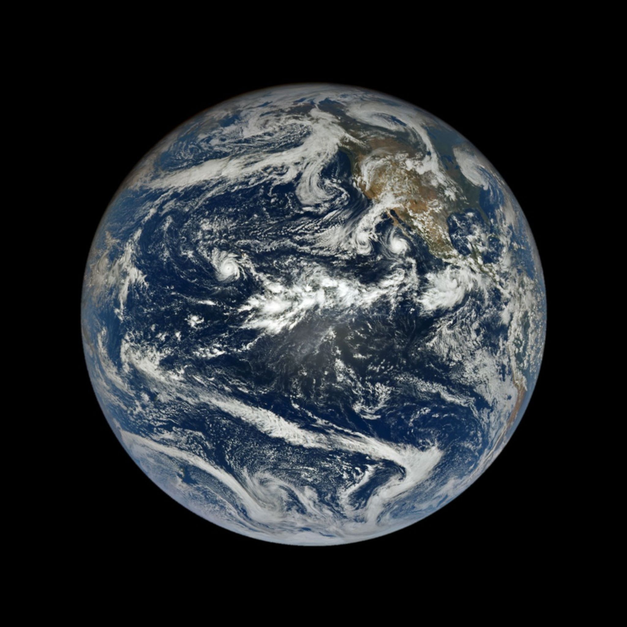
In a full-disk satellite view of Earth, several tropical cyclones swirl above the blue waters of the Pacific Ocean.
The northeastern and central Pacific basins are busy with tropical cyclone activity in this image acquired with NASA’s EPIC (Earth Polychromatic Imaging Camera) on the DSCOVR (Deep Space Climate Observatory) satellite on September 27, 2026. A band of clouds and thunderstorms associated with the Intertropical Convergence Zone (ITCZ) is visible near the center of the image.
NASA Earth Observatory/Lauren Dauphin

The 2026 tropical cyclone season in the northeastern and central Pacific basins has been busy. By September 28, the number of named storms in the region had grown to 20, of which nine had reached hurricane strength. For comparison, the 1991-2020 average by that date is 13.5 named storms with 7.4 hurricanes.

An image from NASA’s EPIC (Earth Polychromatic Imaging Camera) on the DSCOVR (Deep Space Climate Observatory) satellite, acquired on September 27, shows the basin again rife with powerful storms. Hurricane Nolo near Hawaii and Hurricane Polo off the Baja California peninsula were lashing land with high winds, storm surge, and heavy rain. On either side of Polo, Tropical Storm Rachel and Post-Tropical Cyclone Odalys were contributing to treacherous conditions along the Mexican coast and in the southwestern U.S., respectively.

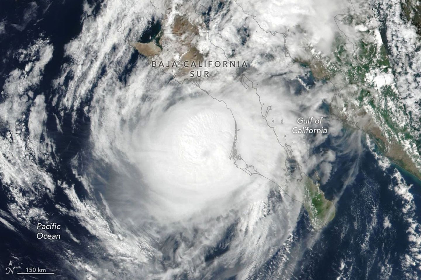
Hurricane Polo (below) made landfall in Baja California Sur around 11 p.m. local time on September 28 (06:00 Universal Time on September 29). Before encountering land, the storm had undergone extreme rapid intensification while churning over the unusually warm ocean surface, catapulting to category 5 status on September 22. Polo waned in intensity on its approach to the coast and likely made landfall as a category 2 storm, according to the National Hurricane Center (NHC).

Hurricane Polo’s clouds spiral over the Pacific Ocean and the Baja California peninsula. The storm’s faint eye is just off the west coast of the peninsula.
Hurricane Polo approaches the coast of Baja California Sur in this image acquired with the VIIRS (Visible Infrared Imaging Radiometer Suite) on the Suomi NPP satellite at 2:20 p.m. local time (21:20 Universal Time) on September 28, 2026.
NASA Earth Observatory/Lauren Dauphin

Polo then continued across the peninsula and the Gulf of California and made a second landfall, near Guaymas, as a further weakened system around midday on September 29. The NHC warned of dangerous winds and storm surge, as well as heavy rains capable of triggering flooding and mudslides in parts of Baja California Sur and Sonora.

The hurricane’s effects were expected to be even more widespread. Polo and its remnants, combined with moisture from Post-Tropical Cyclone Odalys, were likely to push over the southwestern U.S. and southern Plains over several days, forecasters said, fueling yet more heavy rain and flood risk. Next in the train of storms, Tropical Storm Rachel was tracking parallel to the southwest Mexico coast, where the NHC forecast strong winds and dangerous surf and rip current conditions.

Meanwhile, the third hurricane of the season to pass close to Hawaii was delivering yet another deluge to the islands. Hurricane Nolo, though it did not make landfall, dropped more than 12 inches (30 centimeters) of rain on parts of Maui and the Island of Hawaiʻi. The storm flooded roads, toppled trees, and triggered landslides, according to news reports, but the Island of Hawaiʻi was spared some of the more severe effects wrought by Hurricane Lala in mid-August.

As of September 28, the accumulated cyclone energy in the Northeast Pacific was more than twice the norm, according to data from Colorado State University. Scientists expect an increase in tropical cyclone activity in this ocean basin during an El Niño, which has been underway since June. Warm water in the equatorial Pacific and low wind shear in the region, both typical El Niño patterns, encourage tropical storms to develop and strengthen.

The NASA Disasters Program, in coordination with FEMA, is supporting the State of Hawaii’s response to Hurricane Nolo. The team will be posting maps and data products on its open-access mapping portal as new information becomes available.

NASA Earth Observatory images by Lauren Dauphin, using data from DSCOVR EPIC and VIIRS data from NASA EOSDIS LANCE, GIBS/Worldview, and the Suomi National Polar-orbiting Partnership. Story by Lindsey Doermann.

References & Resources

You may also be interested in:

Stay up-to-date with the latest content from NASA as we explore the universe and discover more about our home planet.

Lala Batters Hawaii

3 min read

The powerful storm delivered extreme rainfall and damaging winds to the state, passing the Island of Hawaiʻi as a category…

Article

Explosive Intensification for Hurricane Polo

5 min read

Several ingredients came together off the Pacific coast of Mexico to generate one of the strongest storms the eastern Pacific…

Article

A Trio of Tropical Cyclones in the Pacific

4 min read

The Pacific was buzzing with storms while the Atlantic was notably quiet.

Article

Source: science.nasa.gov