For 18-year-old Hailey Macleod, access to Edwards Air Force Base, Calif., was the realization of a dream with the help of a wish granter at Make-A-Wish Greater Los Angeles and the 412th Test Wing.
Source: www.war.gov
For 18-year-old Hailey Macleod, access to Edwards Air Force Base, Calif., was the realization of a dream with the help of a wish granter at Make-A-Wish Greater Los Angeles and the 412th Test Wing.
Source: www.war.gov
Samuel Huntington and Roger Sherman are two of the four Connecticut delegates among the 56 Founding Fathers who signed the Declaration of Independence on July 4, 1776.
Source: www.war.gov
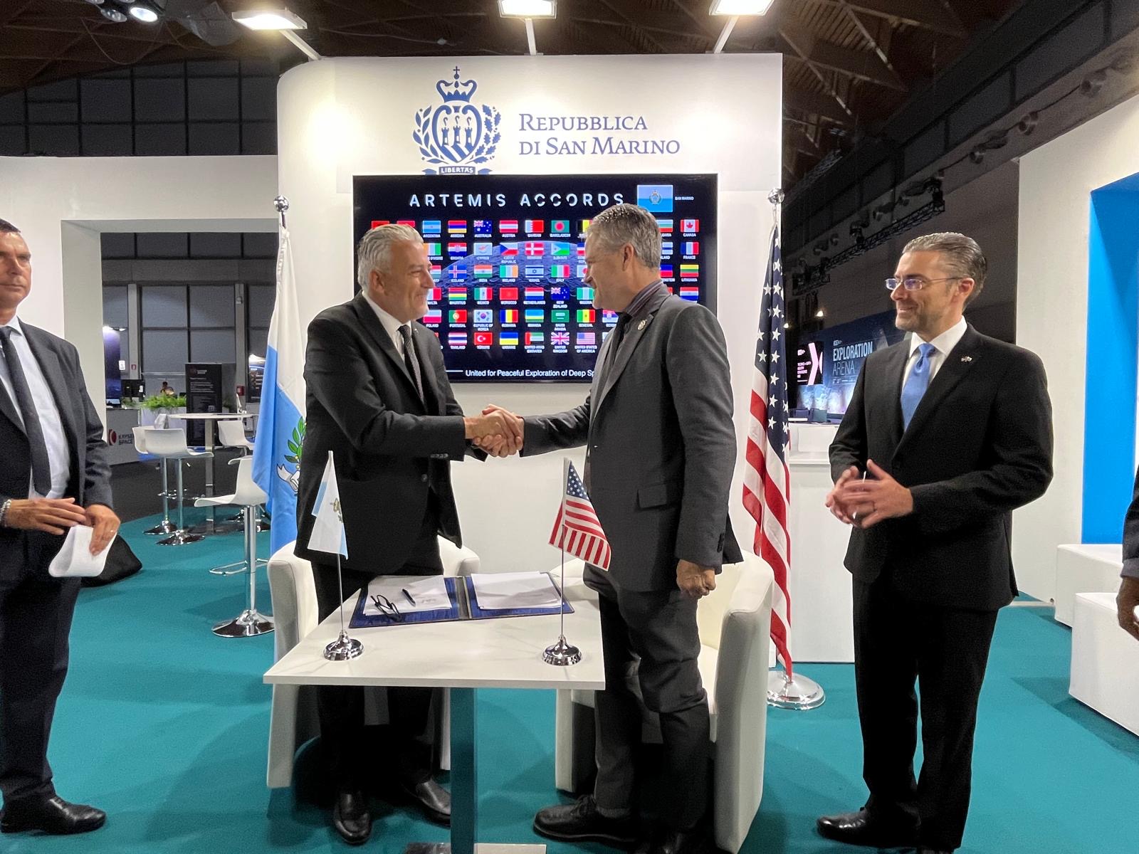
The Republic of San Marino became the 76th signatory to the Artemis Accords during a ceremony in the city of Rimini on Friday with NASA and U.S. Department of State officials present.
“San Marino joins a growing coalition of like-minded nations committed to the peaceful, transparent, and responsible exploration of space,” said NASA Deputy Administrator Matt Anderson. “President Trump has directed NASA to build a Moon Base and establish an enduring presence on the lunar surface. As we do, we are putting the principles of the Accords into practice. NASA has invited every Artemis Accords signatory to participate in our return to the Moon through scientific payloads, technology demonstrations, CubeSats, and other capabilities. San Marino is already looking toward that future.”
Minister of Industry and Technological Research Rossano Fabbri signed on behalf of San Marino. Gregory Mann, NASA Europe representative, participated in the ceremony with the U.S. Consul General in Florence Joseph Tordella.
“We are pleased and honored that the Republic of San Marino has been welcomed as the 76th signatory state of the Artemis Accords,” said Fabbri. “We fully share the principles and values expressed in the Artemis Accords, and we are convinced that the signatory states united under the Accords will make a tangible contribution to promoting international cooperation in space and ensuring the use of space for peaceful purposes.”
In 2020, NASA and the State Department joined with seven other founding nations to establish the Artemis Accords, responding to the growing interest in lunar activities by both governments and private companies. They introduced the first set of practical principles aimed at enhancing the safety and coordination between nations as they explore the Moon, Mars, and beyond, committing nations to:
By signing the Artemis Accords, nations open the door to opportunities for future lunar exploration with NASA, advancing humanity’s return to the Moon, and shaping the Golden Age of exploration and innovation.
Learn more about the Artemis Accords at:
https://www.nasa.gov/artemis-accords
Source: www.nasa.gov
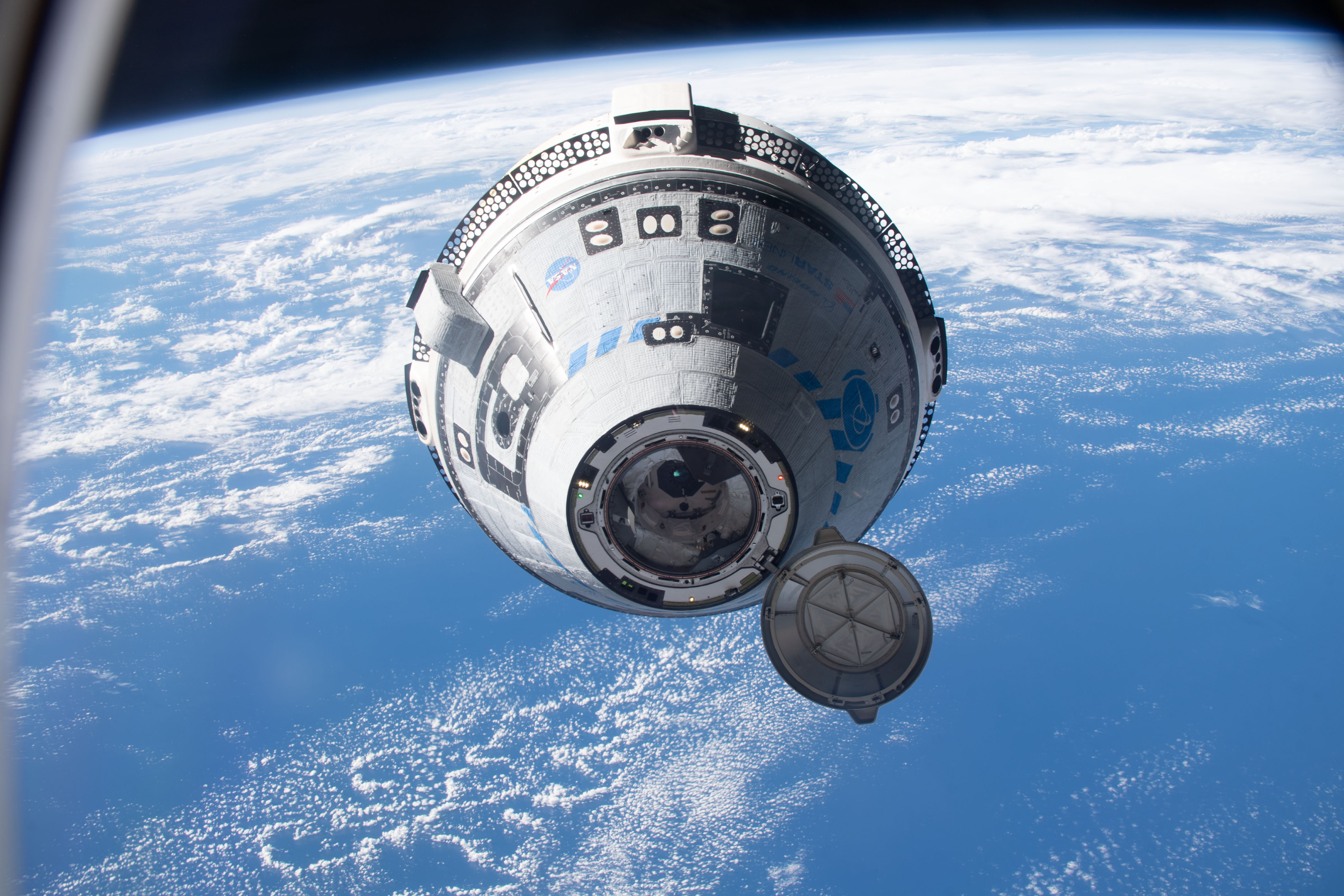
During a news conference at 3 p.m. EDT on Monday, Sept. 28, NASA and Boeing leadership will discuss Starliner’s development and plans for regular crew flights to and from the International Space Station.
Learn where to watch online:
The briefing participants include:
Media already credentialed for Crew-13 may participate in person at NASA’s Kennedy Space Center in Florida. To ask questions, media must request the dial-in number from the Kennedy newsroom by emailing: [email protected] no later than one hour prior to the start of the call. A copy of NASA’s media accreditation policy is online.
For NASA’s blog and more information about the agency’s missions, visit:
-end-
George Alderman / Joshua Finch
Headquarters, Washington
202-358-1600
[email protected] / [email protected]
Source: www.nasa.gov
APOD
Astronomy Picture of the Day
Discover the cosmos! Each day a different image or photograph of our fascinating universe is featured, along with a brief explanation written by a professional astronomer.

Explanation: On August 15, this perseid meteor streaked through night skies over the Observatorio del Roque de los Muchachos at La Palma, Canary Islands, Spain. The bright and colorful meteor trail was captured next to the central Milky Way, whose dark interstellar dust clouds and luminous starlight reach above the horizon. In the foreground of this tantalizing celestial scene is the 23 meter diameter mirror of the prototype Large-Sized Telescope (LST-1). LST-1 is the first telescope constructed at the northern hemisphere site of the innovative Cherenkov Telescope Array Observatory. With 198 hexagonal mirror segments and a large, high-efficiency, pixelized camera, LST-1 is designed to detect extremely brief, atmospheric visible light flashes. Lasting about a billionth of a second, the visible light flashes are triggered by energetic gamma-rays from cosmic sources such as distant active galaxies and gamma-ray bursts. Of course, on that night some individual mirror segments of LST-1 also reflected the atmospheric flash of the bright perseid meteor.
APOD’s email for image submissions has changed. Please see: APOD Submissions.
APOD’s main NASA site is moving: From apod.nasa.gov to science.nasa.gov/apod
Tomorrow’s picture: before and after
| Date | September 26, 2026 |
|---|---|
| Credit & Copyright: | Jeff Dai (TWAN) |
| Authors & editors: | Jerry Bonnell, Cecilia Chirenti, Robert Nemiroff, Keighley Rockcliffe |
| A service of: |
ASD at NASA / GSFC, NASA Science Activation & Michigan Tech. U. |
Source: science.nasa.gov
An Air Force Reservist helped lead a joint three-member U.S. military team to a third-place finish in the novice division at the 2026 International Confederation of Reserve Officers Military Competition in Bucharest, Romania.
Source: www.war.gov
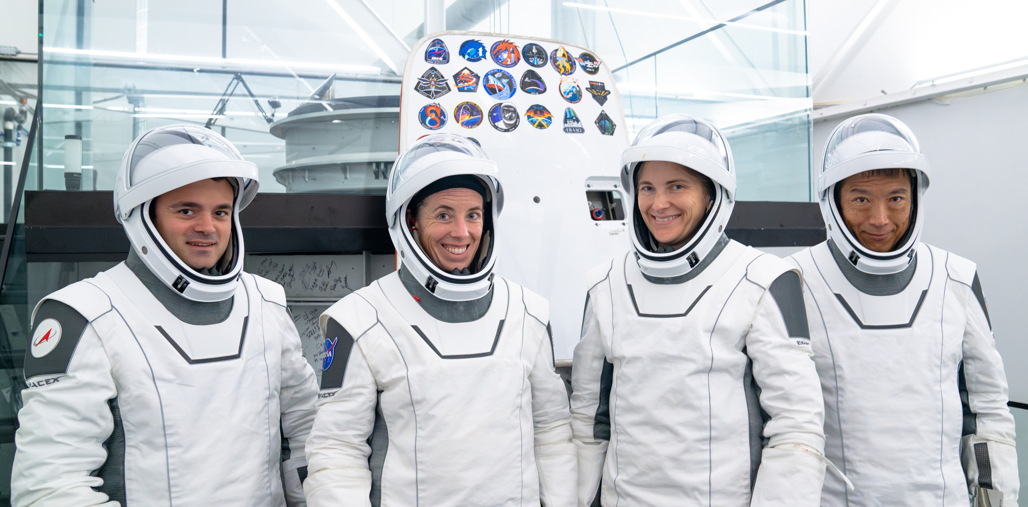
Four crew members from three space agencies will launch to the International Space Station no earlier than spring 2027 for a long-duration science expedition as part of NASA’s SpaceX Crew-14 mission.
NASA astronauts Kayla Barron and Chris Birch will serve as spacecraft commander and pilot, with JAXA (Japan Aerospace Exploration Agency) astronaut Makoto Suwa, and Roscosmos cosmonaut Arutyun Kiviryan as mission specialists. After docking, Crew-14 will join the space station’s Expedition 75/76.
This mission is the 14th commercial crew rotation with SpaceX under NASA’s Low Earth Orbit Program. The crew will conduct scientific investigations and technology demonstrations to help prepare humans for future exploration missions to the Moon and Mars and to benefit people on Earth.
This will be Barron’s second flight to the space station. She was selected as a NASA astronaut in 2017. Barron earned a bachelor’s degree in systems engineering from the U.S. Naval Academy in Annapolis, Maryland and a master’s degree in nuclear engineering from the University of Cambridge in England. A commander in the U.S. Navy, Barron earned her submarine warfare officer qualification, deploying three times aboard the USS Maine. She first launched to the space station in 2021 aboard NASA’s SpaceX Crew-3 mission, spending a total of 177 days in space across space station Expeditions 66/67. She completed two spacewalks and served as lead robotics operator for another. Most recently, Barron supported the development of new technologies and operational concepts for NASA’s Artemis program.
Selected as a NASA astronaut in 2021, Birch graduated from the University of Arizona in Tucson with degrees in mathematics and biochemistry and molecular biophysics. She earned a doctorate in biological engineering from the Massachusetts Institute of Technology, and later taught bioengineering at the University of California, Riverside, and scientific writing and communication at the California Institute of Technology in Pasadena. Birch competed as a decorated track cyclist on the U.S. National Team and was named to the Olympic Long Team for the 2020 Tokyo Games. She has served as a capsule communicator, supporting crews aboard the space station and during the Artemis II mission. Birch was crew lead for Expedition 72, working with flight control teams to help manage daily operations, and served as a crew representative for NASA’s Orion Program, supporting Artemis II mission development and operations. This will be her first spaceflight.
The Crew-14 mission also is the first spaceflight assignment for Suwa. Before JAXA selected him as an astronaut candidate in 2023, Suwa spent nearly a decade with the World Bank Group. Previously, he served in Rwanda as a Japan Overseas Cooperation Volunteer before joining the United Nations World Meteorological Organization. Suwa holds a doctorate in geosciences from Princeton University and completed basic training to become certified as an astronaut in 2024.
This mission will be Kiviryan’s first trip to the space station. He graduated from Saint Petersburg Suvorov Military School in 2010 and later studied at the Baltic State Technical University. He graduated in 2015 as an engineer specializing in rocket science and completed training in the operation of computer-controlled machines. Kiviryan was selected for the Gagarin Research and Test Cosmonaut Training Center Cosmonaut Corps in 2021 and has served as a test cosmonaut since 2023.
For more than 25 years, people have lived and worked continuously aboard the International Space Station, advancing scientific knowledge and making research breakthroughs that aren’t possible on Earth. The space station helps NASA understand and overcome the challenges of human spaceflight, expand commercial opportunities in low Earth orbit, and build on the foundation for long-duration missions to the Moon, as part of the Artemis program, and to Mars.
Learn more about International Space Station research and operations at:
-end-
Joshua Finch / Jimi Russell
Headquarters, Washington
202-358-1100
[email protected] / [email protected]
Anna Schneider / Mary Pfister
Johnson Space Center, Houston
281-483-5111
[email protected] / [email protected]
Source: www.nasa.gov

Côte d’Ivoire signed the Artemis Accords on Thursday, becoming the 75th signatory and marking a major milestone for this growing coalition. With the signing ceremony in the nation’s largest city, Abidjan, Côte d’Ivoire joined other like-minded nations and committed to the peaceful, transparent, and responsible exploration of the Moon, Mars, and beyond.
“The United States and Côte d’Ivoire already cooperate on Earth,” said NASA’s Deputy Administrator Matt Anderson. “Today, we expand that partnership beyond it. Joining the Artemis Accords opens new opportunities for our scientists, engineers, and institutions to work together as humanity returns to the Moon and prepares for what comes next. We’ve aligned on the principles. The opportunities are in front of us. And now we can get to work.”
The nation’s Minister of Higher Education and Scientific Research Adama Diawara signed on behalf of the country in a ceremony held during Africa Space Expo ASPEX 2026. Chargé d’affaires Junaid Munir from the U.S. Department of State witnessed the ceremony.
“This is a great achievement, and important for Côte d’Ivoire’s ambitions and for the rest of the African Union members,” said Director General of the Space Agency of Côte d’Ivoire Tidiane Outtara.
Côte d’Ivoire has expanded its involvement in space science and technology through years of international cooperation. Since 2019, the National Office of Technical Development of Côte d’Ivoire and NASA have collaborated on Earth observation and geodesy, a field that measures Earth’s shape, gravity, and movement. Together, the partners have advanced global geodetic networks, improved space‑based measurement techniques, and increased understanding of how Earth’s systems interact.
The country later established the Space Agency of Côte d’Ivoire in 2025 to coordinate national efforts in Earth observation, space weather, astronomy, satellite navigation, and communications.
In 2020, NASA and the State Department joined with seven other founding nations to establish the Artemis Accords, responding to the growing interest in lunar activities by both governments and private companies. The Artemis Accords are the first set of practical principles aimed at enhancing transparency, safety, and coordination among nations as they explore the Moon, Mars, and beyond, committing nations to:
By signing the Artemis Accords, nations open the door to opportunities for future lunar exploration with NASA, advancing humanity’s return to the Moon, and shaping the Golden Age of exploration and innovation.
Learn more about the Artemis Accords at:
https://www.nasa.gov/artemis-accords
Source: www.nasa.gov
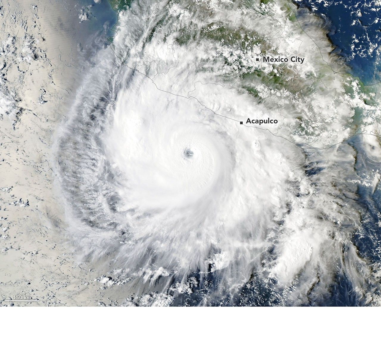
In mid-September 2026, Hurricane Polo began as a tropical disturbance off the Pacific coast of Mexico. By September 20, it was organized enough to qualify as a tropical depression, and by the next day it was a tropical storm.
From there, Polo launched into a period of rapid intensification that left meteorologists searching for adjectives strong enough to convey what was happening. Some described the storm’s rate of intensification and strength as “jaw-dropping,” others as “astonishing,” and others as “absolute insanity.”
“Polo went through a period of what can only be described as explosively rapid intensification,” said Gary Partyka, an atmospheric scientist with the Global Modeling and Assimilation Office (GMAO) at NASA’s Goddard Space Flight Center, in an email. “This was RAPID, rapid intensification.”
The storm was in an environment that was “near perfect” for strengthening, Partyka said, characterized by weak wind shear, high moisture, warmer ocean temperatures, and high levels of atmospheric instability.
Several observers leaned on extreme rapid intensification—a technical classification meaning the storm’s wind speeds increased at least 60 knots (111 kilometers or 69 miles per hour) within a 24-hour period. By September 22, the storm’s maximum sustained wind speed had risen by 90 knots (167 kilometers per hour or 104 miles per hour) within 24 hours, hitting category 5 strength. In its normally staid forecast discussions, the National Hurricane Center called the intensification “truly remarkable.”
When NOAA’s Hurricane Hunter aircraft flew over the storm on September 22, researchers estimated winds of nearly 285 kilometers (180 miles) per hour. That would make it the third-strongest storm on record in the eastern Pacific by maximum sustained winds and the fastest on record to go from a tropical depression to a category 5 storm, according to some analysts.
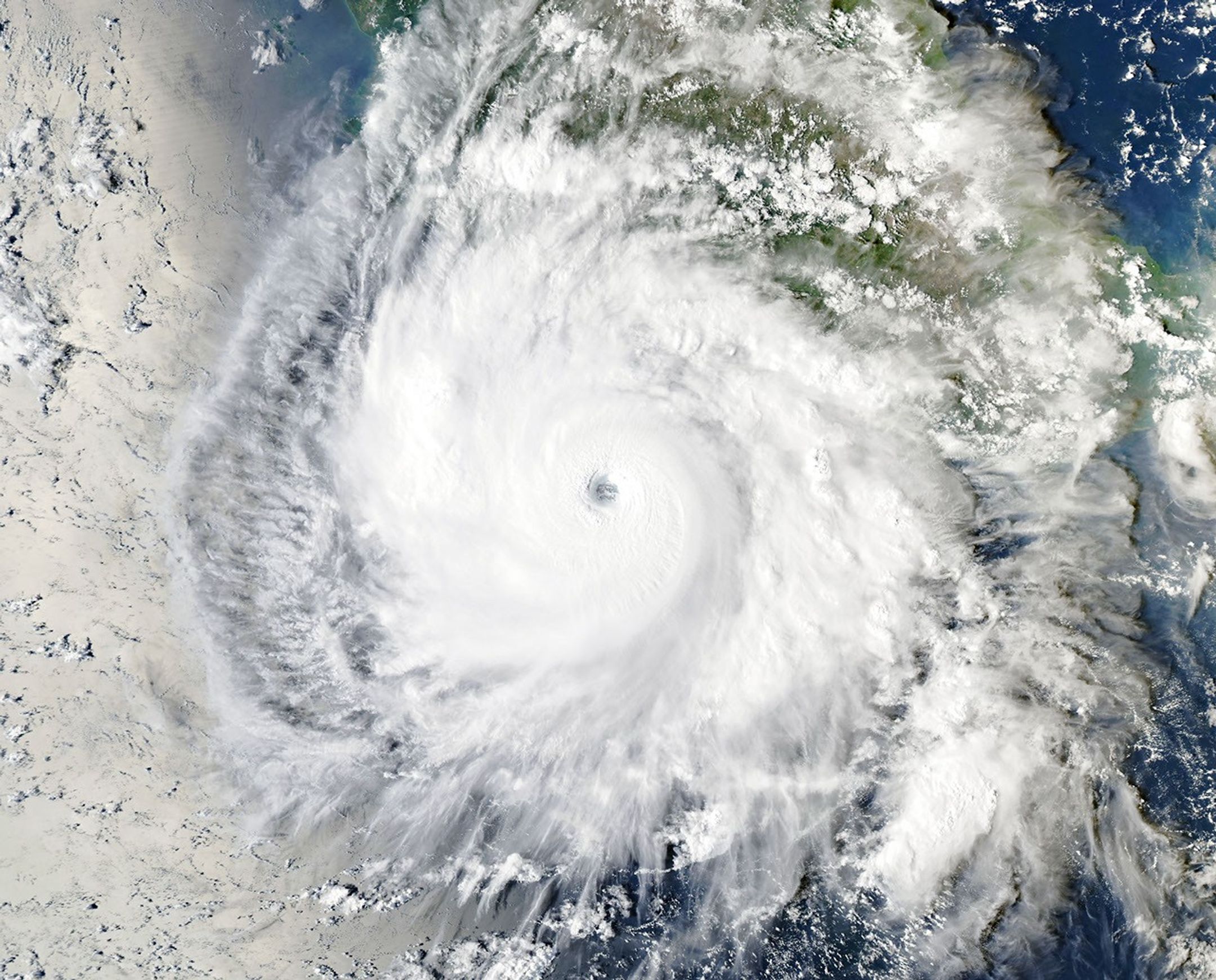
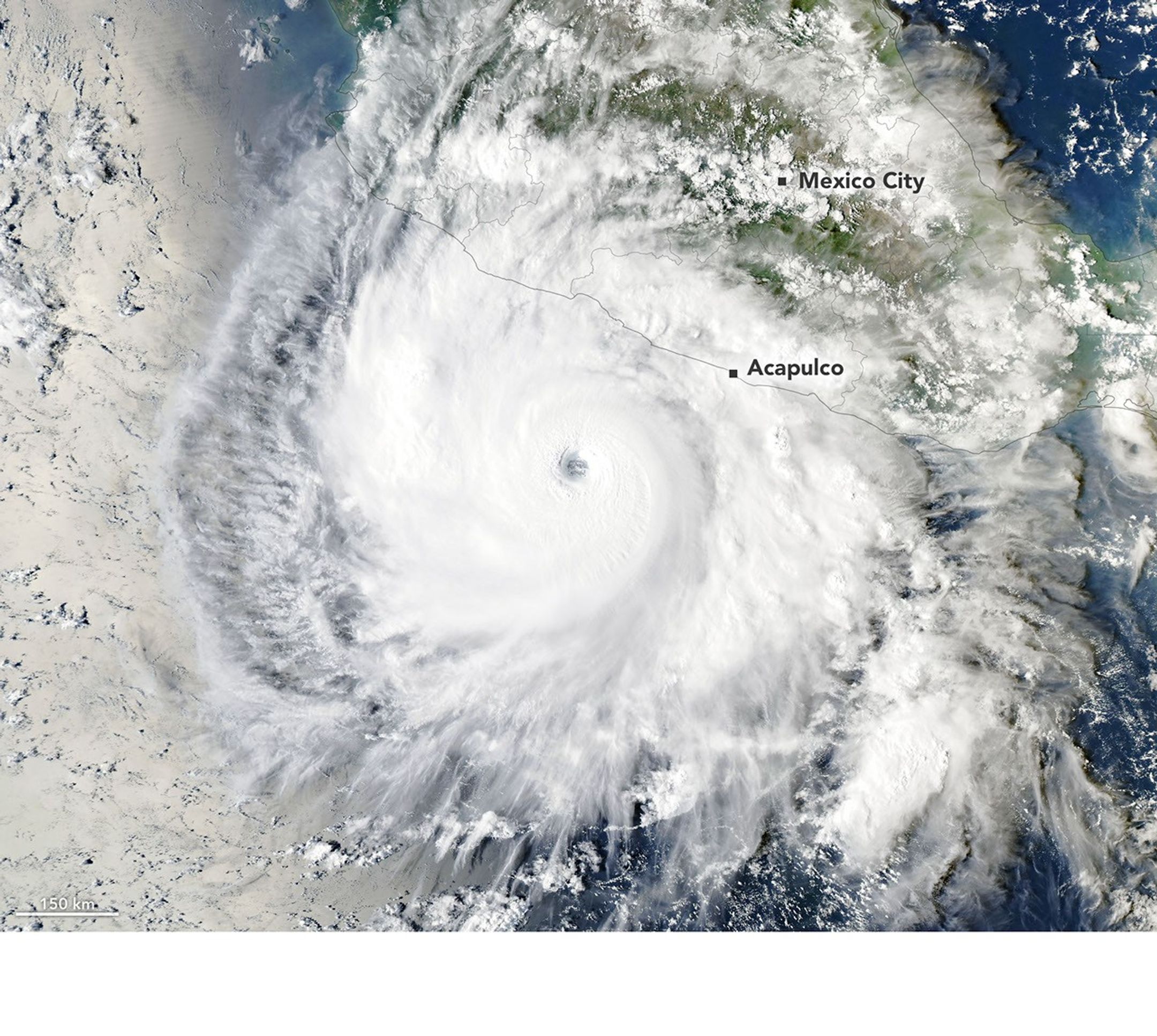
On the afternoon of September 23, when the Moderate Resolution Imaging Spectroradiometer (MODIS) on NASA’s Aqua satellite captured this image (left), Polo was churning off the coast of Guerrero, southwest of Acapulco. With maximum sustained winds of 230 kilometers (145 miles) per hour, the storm was category 4 strength when the image was acquired, having undergone an eyewall replacement cycle that weakened it slightly.
“The satellite imagery of Polo is very impressive, with the storm’s large, clear eye and extensive outflow pattern,” said Kristen Corbosiero, an atmospheric scientist at the State University of New York at Albany, who is working on a NASA project that uses satellite data to study tropical cyclone ventilation. “Weak winds above the system and good outflow at the top of the system also contributed to Polo’s rapid intensification.”
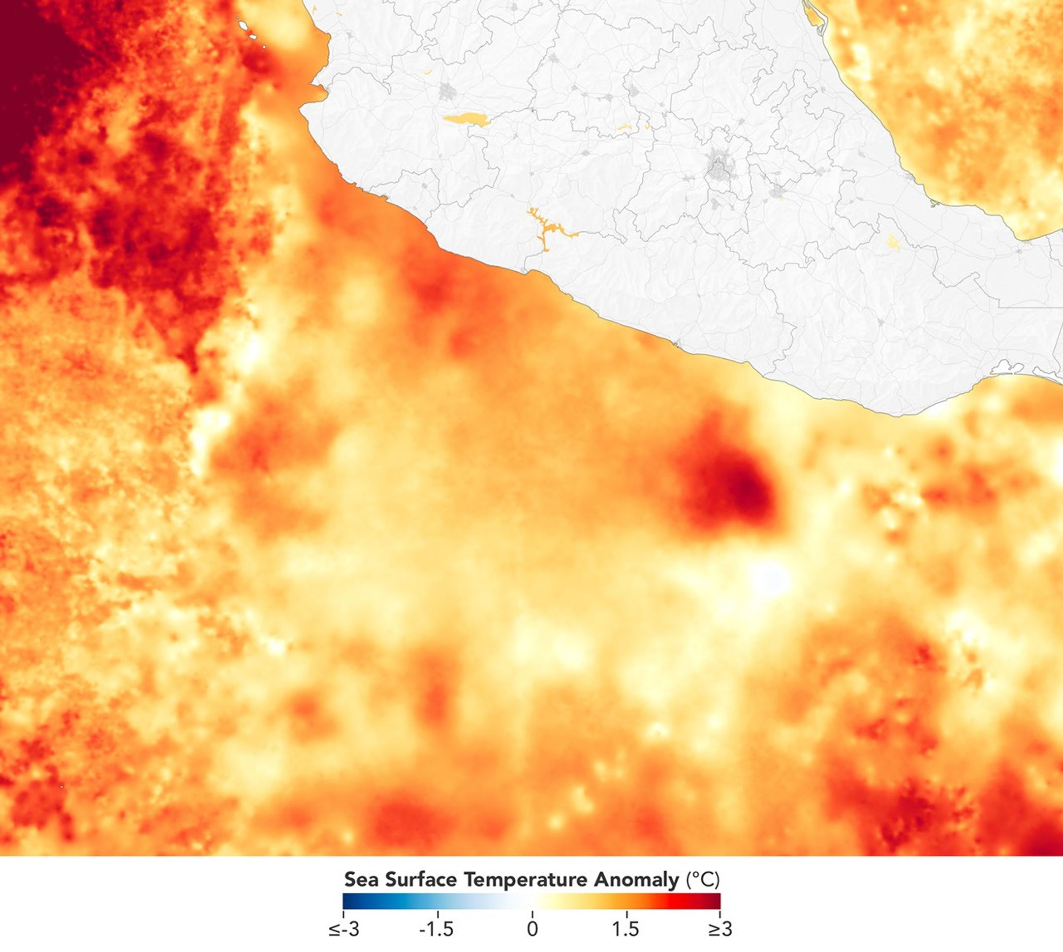
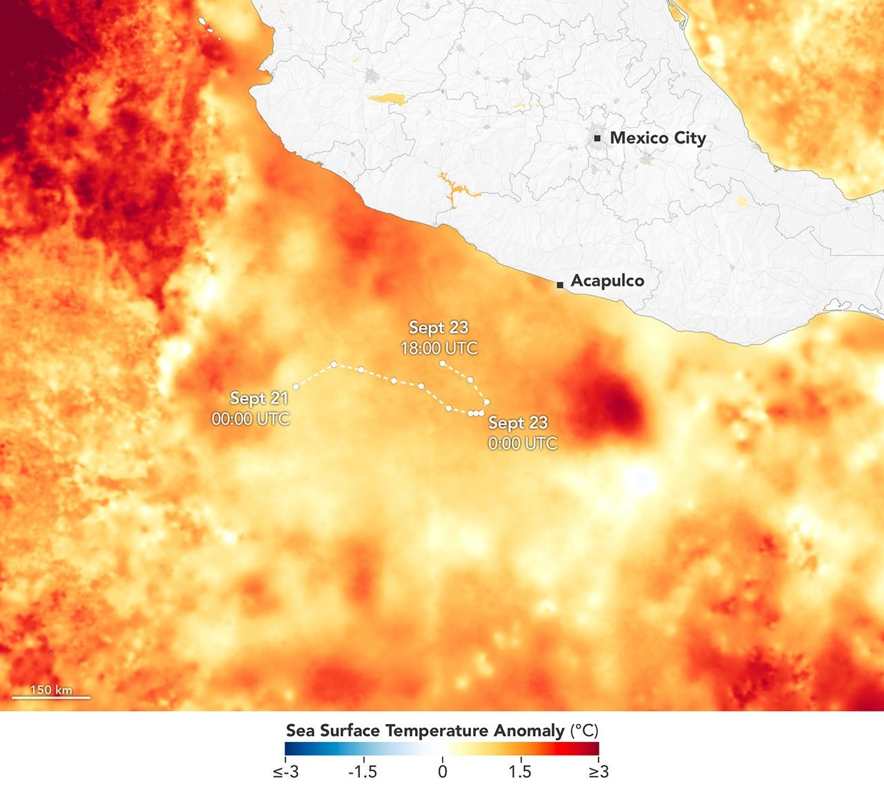
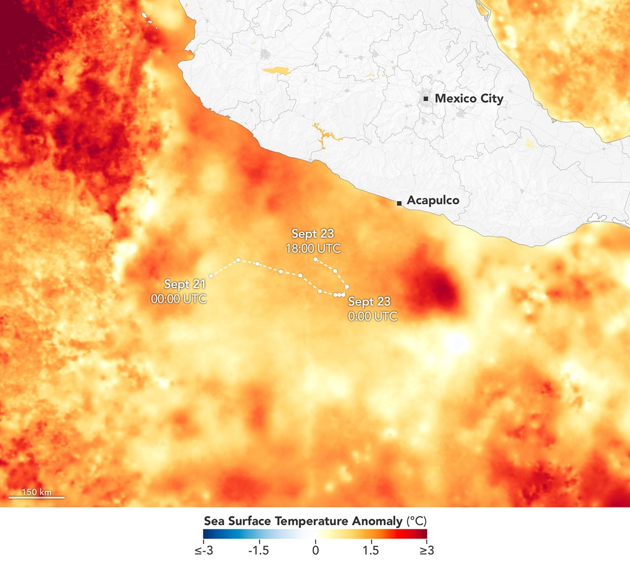
As Polo developed, it moved over areas where sea surface temperatures were as high as 32 degrees Celsius (90 degrees Fahrenheit)—2 to 3 degrees warmer than usual for September 23. Surface waters across much of the region were above 27.8°C (82°F), the temperature generally required to sustain and intensify hurricanes.
The map above (right) is based on data from the Multiscale Ultrahigh Resolution Sea Surface Temperature (MUR SST) project at NASA’s Jet Propulsion Laboratory, which blends satellite measurements from NASA, NOAA, and international missions with observations from ships and buoys. Rather than absolute temperatures, the map shows anomalies—how much warmer or cooler the ocean surface was on September 23, 2026, than the project’s 2003-2014 average for that date.
While the map above conveys temperatures at the water surface, the presence of warm water deeper in the column has likely contributed to the storm’s staying power, Corbosiero added. Sometimes hurricanes churn up cooler water from deep in the column that can slow a storm’s intensification, but in this case the cool water wake behind the storm appears minimal, and measurements and models show high ocean heat content at considerable depths.
Both Partyka and Corbosiero cautioned against attributing Polo’s rapid intensification directly to El Niño’s unusually warm surface temperatures in the central and eastern Pacific Ocean. Several hurricanes in this region have undergone rapid intensification in the past during La Niña and neutral conditions, Corbosiero noted, including Hurricane Otis in 2023 and Patricia in 2015, both category 5 storms.
However, the overall amount of tropical cyclone activity in the eastern Pacific does typically increase during El Niño due to changes in large-scale ocean and atmospheric circulation patterns, and that’s what has happened so far in 2026. As of September 24, the accumulated cyclone energy in the region was nearly twice the norm, according to data from Colorado State University.
People tracking sea surface temperature anomalies or other aspects of the storm can do so using NASA’s Worldview browser, a near real-time data viewer from the Short-term Prediction Research and Transition (SPoRT) project, and the FLUID tool from GMAO. Forecasters expect Polo to stay over the Pacific until next week, when it may curve toward the northeast and approach Baja California.
NASA Earth Observatory images by Michala Garrison, using sea surface temperature data from the Multiscale Ultrahigh Resolution (MUR) project, MODIS data from NASA EOSDIS LANCE and GIBS/Worldview, and storm track data from NOAA’s National Hurricane Center. Story by Adam Voiland.
Stay up-to-date with the latest content from NASA as we explore the universe and discover more about our home planet.

The powerful storm delivered extreme rainfall and damaging winds to the state, passing the Island of Hawaiʻi as a category…

The first named storm of the 2026 Atlantic hurricane season brought intense rainfall and the threat of flash flooding to…
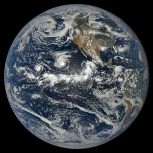
The Pacific was buzzing with storms while the Atlantic was notably quiet.
Source: science.nasa.gov
APOD
Astronomy Picture of the Day
Discover the cosmos! Each day a different image or photograph of our fascinating universe is featured, along with a brief explanation written by a professional astronomer.
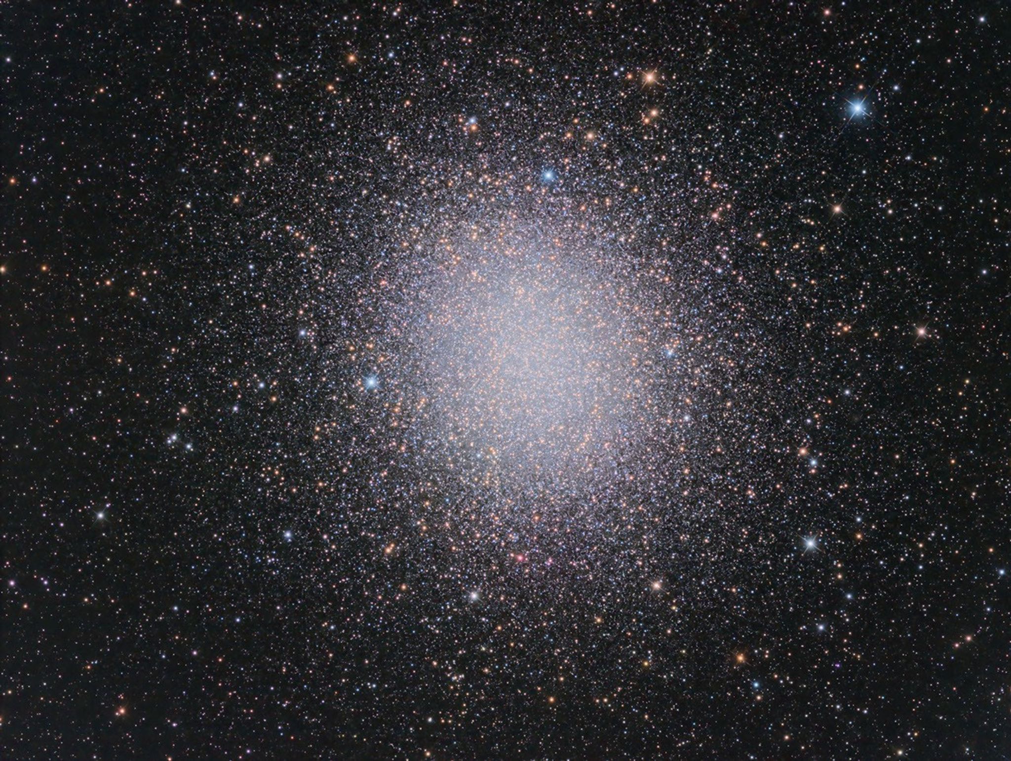
Explanation: Globular star cluster Omega Centauri packs about 10 million stars much older than the Sun into a volume some 150 light-years in diameter. Also known as NGC 5139, at a distance of 15,000 light-years it’s the largest and brightest of 200 or so known globular clusters that roam the halo of our Milky Way galaxy. Though most star clusters consist of stars with the same age and composition, the enigmatic Omega Cen exhibits the presence of different stellar populations with a spread of ages and chemical abundances. In fact, Omega Cen may be the remnant core of a small galaxy merging with the Milky Way. With a yellowish hue, Omega Centauri’s red giant stars are easy to pick out in this sharp telescopic view. A two-decade-long exploration of the dense star cluster with the Hubble Space Telescope has revealed evidence for a massive black hole near the center of Omega Centauri.
APOD’s email for image submissions has changed. Please see: APOD Submissions.
APOD’s main NASA site is moving: From apod.nasa.gov to science.nasa.gov/apod
Tomorrow’s picture: reflections on a starry night
| Date | September 25, 2026 |
|---|---|
| Credit & Copyright: | Javier O. Cadenas Parra |
| Authors & editors: | Jerry Bonnell, Cecilia Chirenti, Robert Nemiroff, Keighley Rockcliffe |
| A service of: |
ASD at NASA / GSFC, NASA Science Activation & Michigan Tech. U. |
Source: science.nasa.gov